Landing elevation
Landing (New Jersey, Morris County), United States elevation is 286 meters and Landing elevation in feet is 938 ft above sea level [src 1]. Landing is a populated place (feature code) with elevation that is 7 meters (23 ft) bigger than average city elevation in United States.
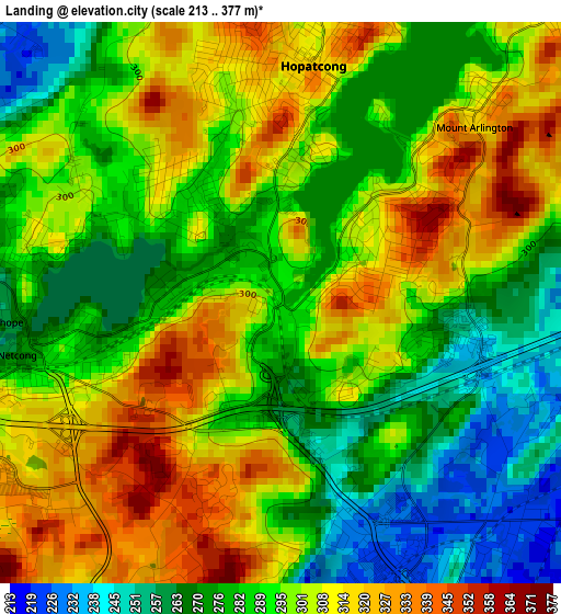
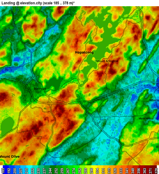
Below is the Elevation map of Landing, which displays elevation range with different colors. Scale of the first map is from 213 to 377 m (699 to 1237 ft) with average elevation of 294.2 meters (=965 ft) [note 1]
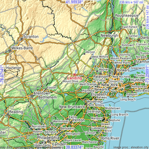
These maps also provides idea of topography and contour of this city, they are displayed at different zoom levels. More info about maps, scale and edge coordinates you can find below images.
| \ | Map #1 | Map #2 | Topo.Map |
| Scale [m] | 213..377 m | 185..378 m | × |
| Scale [ft] | 699..1237 ft | 607..1240 ft | × |
| Average | 294.2 m = 965 ft | 279.4 m = 917 ft | × |
| Width | 7.39 km = 4.6 mi | 14.77 km = 9.2 mi | 236.3 km = 146.8 mi |
| Height | 7.39 km = 4.6 mi | 14.77 km = 9.2 mi | 236.3 km = 146.8 mi |
| ↑Max Latitude | 40.938305° | 40.971494° | 41.95938° |
| Latitude at center | 40.9051° | 40.9051° | 40.9051° |
| ↓Min Latitude | 40.871878° | 40.838639° | 39.83374° |
| ← Min Longitude | -74.709105° | -74.753051° | -76.07141° |
| Longitude center | -74.66516° | -74.66516° | -74.66516° |
| →Max Longitude | -74.621215° | -74.577269° | -73.25891° |
Nearby cities:
Cities around Landing sort by population:
• Randolph elevation 298 m
9.5 km,  131°
131°
• Dover 181 m
9 km,  105°
105°
• Hopatcong Hills 346 m
4.3 km,  353°
353°
• Hopatcong 317 m
3.1 km,  9°
9°
• Succasunna 223 m
4.6 km,  152°
152°
• Budd Lake 291 m
6.9 km,  236°
236°
• Wharton 213 m
7.1 km,  100°
100°
• Mount Arlington 315 m
3.4 km,  47°
47°
• Stanhope 262 m
3.7 km,  266°
266°
• Netcong 267 m
3.5 km,  258°
258°
• Kenvil 222 m
4.8 km, 125°
• Victory Gardens 190 m
10.8 km, 107°
Multilingual:
 En español:
Landing elevación 286 m.
 En France:
Landing élévation 286 m.


Sources and notes:
- [note 1] Map square and city borders are not equal. Map elevation data is calculated only from area inside that square.
- [src 1] Elevation data from geonames database provided with same terms of usage.
- [src 2] The elevation map of Landing is generated using elevation data from NASA's 3 arcsec (90m) resolution SRTM data.
- [src 3] Base (background) map © OpenStreetMap contributors tiles are generated by Geofabrik and OpenTopoMap.
Copyright & License:
This Landing Elevation Map is licensed under CC BY-SA. You may reuse any part from this page, if you give a proper credit by linking to this URL:
 More info on terms of use page.