Weare elevation
Weare (New Hampshire, Hillsborough County), United States elevation is 194 meters and Weare elevation in feet is 636 ft above sea level [src 1]. Weare is a populated place (feature code) with elevation that is 85 meters (279 ft) smaller than average city elevation in United States.
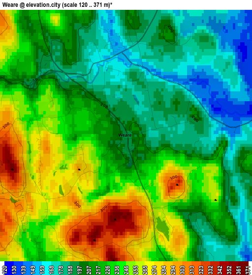
Below is the Elevation map of Weare, which displays elevation range with different colors. Scale of the first map is from 120 to 371 m (394 to 1217 ft) with average elevation of 221.8 meters (=728 ft) [note 1]
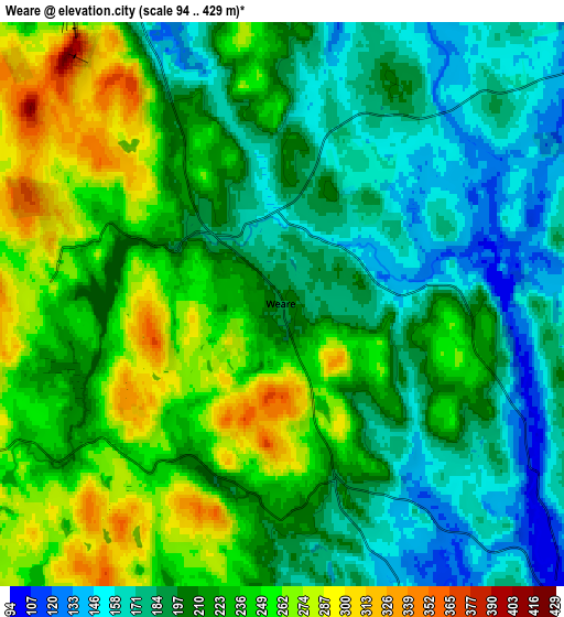
These maps also provides idea of topography and contour of this city, they are displayed at different zoom levels. More info about maps, scale and edge coordinates you can find below images.
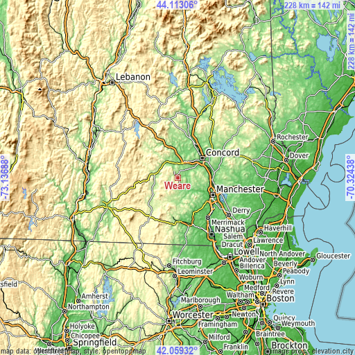
| \ | Map #1 | Map #2 | Topo.Map |
| Scale [m] | 120..371 m | 94..429 m | × |
| Scale [ft] | 394..1217 ft | 308..1407 ft | × |
| Average | 221.8 m = 728 ft | 214.9 m = 705 ft | × |
| Width | 7.14 km = 4.4 mi | 14.27 km = 8.9 mi | 228.4 km = 141.9 mi |
| Height | 7.14 km = 4.4 mi | 14.27 km = 8.9 mi | 228.3 km = 141.9 mi |
| ↑Max Latitude | 43.126882° | 43.158946° | 44.11306° |
| Latitude at center | 43.0948° | 43.0948° | 43.0948° |
| ↓Min Latitude | 43.062702° | 43.030587° | 42.05932° |
| ← Min Longitude | -71.774575° | -71.818521° | -73.13688° |
| Longitude center | -71.73063° | -71.73063° | -71.73063° |
| →Max Longitude | -71.686685° | -71.642739° | -70.32438° |
Nearby cities:
Cities around Weare sort by population:
• Concord elevation 87 m
20.1 km,  51°
51°
• Bow Bog 130 m
18 km,  80°
80°
• Hopkinton 157 m
11.6 km,  22°
22°
• New Boston 151 m
13.5 km,  167°
167°
• Goffstown 97 m
13.4 km,  128°
128°
• Deering 334 m
9.6 km,  255°
255°
• Hillsborough 198 m
13.9 km,  278°
278°
• Greenfield 262 m
19.7 km,  215°
215°
• Henniker 137 m
12 km,  321°
321°
• Francestown 258 m
13.7 km,  209°
209°
• Contoocook 113 m
14.2 km,  5°
5°
• Antrim 218 m
18.4 km,  247°
247°
Multilingual:
 En español:
Weare elevación 194 m.
 En France:
Weare élévation 194 m.


Sources and notes:
- [note 1] Map square and city borders are not equal. Map elevation data is calculated only from area inside that square.
- [src 1] Elevation data from geonames database provided with same terms of usage.
- [src 2] The elevation map of Weare is generated using elevation data from NASA's 3 arcsec (90m) resolution SRTM data.
- [src 3] Base (background) map © OpenStreetMap contributors tiles are generated by Geofabrik and OpenTopoMap.
Copyright & License:
This Weare Elevation Map is licensed under CC BY-SA. You may reuse any part from this page, if you give a proper credit by linking to this URL:
 More info on terms of use page.