Farmington elevation
Farmington (New Hampshire, Strafford County), United States elevation is 87 meters and Farmington elevation in feet is 285 ft above sea level [src 1]. Farmington is a populated place (feature code) with elevation that is 192 meters (630 ft) smaller than average city elevation in United States.
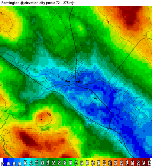
Below is the Elevation map of Farmington, which displays elevation range with different colors. Scale of the first map is from 72 to 275 m (236 to 902 ft) with average elevation of 151.1 meters (=496 ft) [note 1]
These maps also provides idea of topography and contour of this city, they are displayed at different zoom levels. More info about maps, scale and edge coordinates you can find below images.
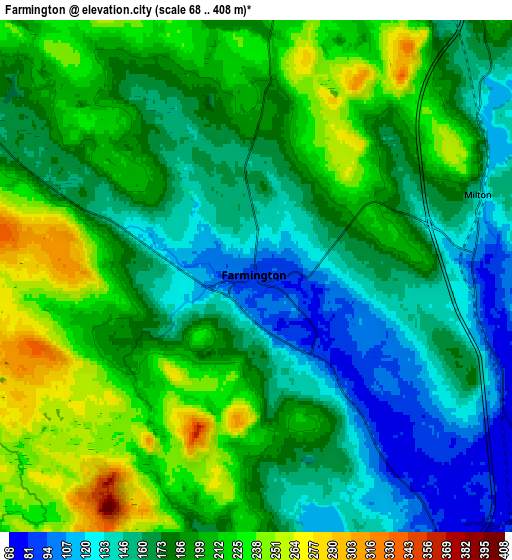
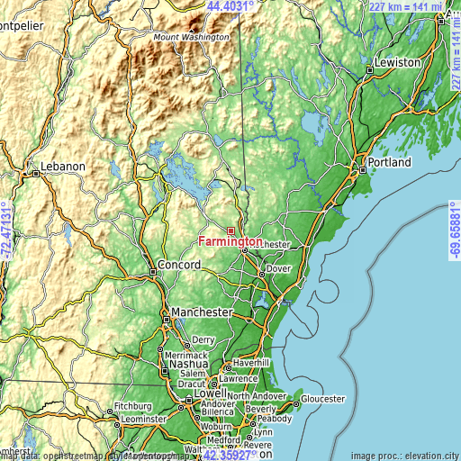
| \ | Map #1 | Map #2 | Topo.Map |
| Scale [m] | 72..275 m | 68..408 m | × |
| Scale [ft] | 236..902 ft | 223..1339 ft | × |
| Average | 151.1 m = 496 ft | 182.9 m = 600 ft | × |
| Width | 7.1 km = 4.4 mi | 14.2 km = 8.8 mi | 227.3 km = 141.2 mi |
| Height | 7.1 km = 4.4 mi | 14.2 km = 8.8 mi | 227.2 km = 141.2 mi |
| ↑Max Latitude | 43.421727° | 43.453636° | 44.4031° |
| Latitude at center | 43.3898° | 43.3898° | 43.3898° |
| ↓Min Latitude | 43.357857° | 43.325896° | 42.35927° |
| ← Min Longitude | -71.109005° | -71.152951° | -72.47131° |
| Longitude center | -71.06506° | -71.06506° | -71.06506° |
| →Max Longitude | -71.021115° | -70.977169° | -69.65881° |
Nearby cities:
Cities around Farmington sort by population:
• Rochester elevation 73 m
11.9 km,  142°
142°
• Somersworth 69 m
21.5 km,  131°
131°
• Barrington 117 m
18.6 km,  175°
175°
• Lebanon 90 m
17.3 km,  88°
88°
• Wakefield 210 m
20 km,  8°
8°
• Barnstead 156 m
19.4 km,  251°
251°
• Northwood 173 m
22.8 km,  197°
197°
• Strafford 200 m
11.9 km,  234°
234°
• New Durham 165 m
10.1 km,  301°
301°
• Acton 221 m
20.4 km,  37°
37°
• Berwick 57 m
21.3 km, 130°
• Sanbornville 176 m
18.5 km, 8°
Multilingual:
 En español:
Farmington elevación 87 m.
 En France:
Farmington élévation 87 m.
 Auf Deutsch:
Farmington höhe über dem Meeresspiegel ist 87 m.

Sources and notes:
- [note 1] Map square and city borders are not equal. Map elevation data is calculated only from area inside that square.
- [src 1] Elevation data from geonames database provided with same terms of usage.
- [src 2] The elevation map of Farmington is generated using elevation data from NASA's 3 arcsec (90m) resolution SRTM data.
- [src 3] Base (background) map © OpenStreetMap contributors tiles are generated by Geofabrik and OpenTopoMap.
Copyright & License:
This Farmington Elevation Map is licensed under CC BY-SA. You may reuse any part from this page, if you give a proper credit by linking to this URL:
 More info on terms of use page.