Epsom elevation
Epsom (New Hampshire, Merrimack County), United States elevation is 124 meters and Epsom elevation in feet is 407 ft above sea level [src 1]. Epsom is a populated place (feature code) with elevation that is 155 meters (509 ft) smaller than average city elevation in United States.
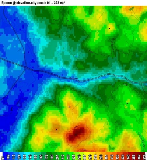
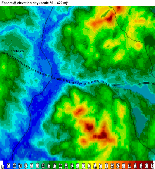
Below is the Elevation map of Epsom, which displays elevation range with different colors. Scale of the first map is from 91 to 378 m (299 to 1240 ft) with average elevation of 189.1 meters (=620 ft) [note 1]
These maps also provides idea of topography and contour of this city, they are displayed at different zoom levels. More info about maps, scale and edge coordinates you can find below images.
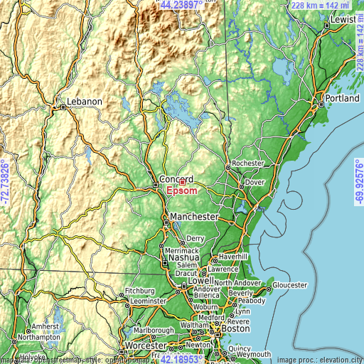
| \ | Map #1 | Map #2 | Topo.Map |
| Scale [m] | 91..378 m | 89..422 m | × |
| Scale [ft] | 299..1240 ft | 292..1385 ft | × |
| Average | 189.1 m = 620 ft | 197 m = 646 ft | × |
| Width | 7.12 km = 4.4 mi | 14.24 km = 8.8 mi | 227.9 km = 141.6 mi |
| Height | 7.12 km = 4.4 mi | 14.24 km = 8.8 mi | 227.9 km = 141.6 mi |
| ↑Max Latitude | 43.254874° | 43.286872° | 44.23897° |
| Latitude at center | 43.22286° | 43.22286° | 43.22286° |
| ↓Min Latitude | 43.190829° | 43.158781° | 42.18953° |
| ← Min Longitude | -71.375955° | -71.419901° | -72.73826° |
| Longitude center | -71.33201° | -71.33201° | -71.33201° |
| →Max Longitude | -71.288065° | -71.244119° | -69.92576° |
Nearby cities:
Cities around Epsom sort by population:
• Concord elevation 87 m
16.7 km,  264°
264°
• East Concord 100 m
16.8 km,  277°
277°
• Pembroke 130 m
13.2 km,  230°
230°
• Suncook 83 m
14.2 km,  223°
223°
• Barnstead 156 m
12.8 km,  14°
14°
• Candia 114 m
16.7 km,  164°
164°
• Hooksett 63 m
17.7 km, 217°
• Northwood 173 m
15 km,  102°
102°
• Strafford 200 m
16.7 km,  45°
45°
• Chichester 166 m
6.2 km,  298°
298°
• Pittsfield 150 m
9.3 km,  3°
3°
• Allenstown 104 m
9.4 km, 218°
Multilingual:
 En español:
Epsom elevación 124 m.
 En France:
Epsom élévation 124 m.


Sources and notes:
- [note 1] Map square and city borders are not equal. Map elevation data is calculated only from area inside that square.
- [src 1] Elevation data from geonames database provided with same terms of usage.
- [src 2] The elevation map of Epsom is generated using elevation data from NASA's 3 arcsec (90m) resolution SRTM data.
- [src 3] Base (background) map © OpenStreetMap contributors tiles are generated by Geofabrik and OpenTopoMap.
Copyright & License:
This Epsom Elevation Map is licensed under CC BY-SA. You may reuse any part from this page, if you give a proper credit by linking to this URL:
 More info on terms of use page.