Bedford elevation
Bedford (New Hampshire, Hillsborough County), United States elevation is 96 meters and Bedford elevation in feet is 315 ft above sea level [src 1]. Bedford is a populated place (feature code) with elevation that is 183 meters (600 ft) smaller than average city elevation in United States.
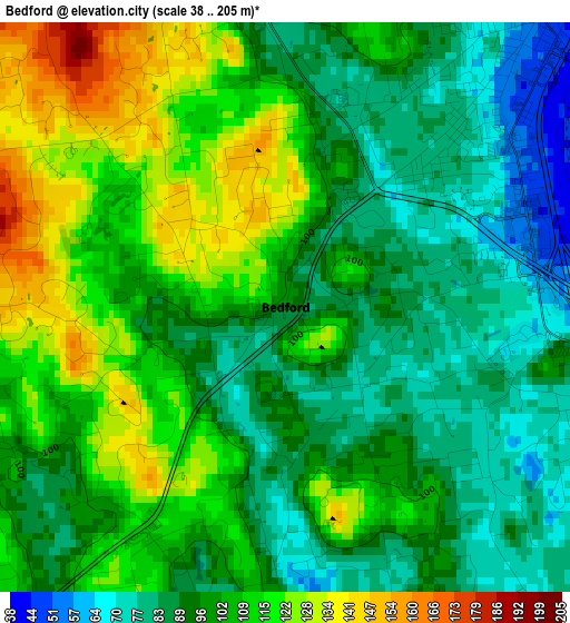
Below is the Elevation map of Bedford, which displays elevation range with different colors. Scale of the first map is from 38 to 205 m (125 to 673 ft) with average elevation of 100.5 meters (=330 ft) [note 1]
These maps also provides idea of topography and contour of this city, they are displayed at different zoom levels. More info about maps, scale and edge coordinates you can find below images.
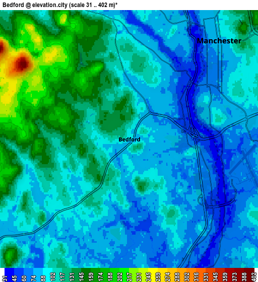
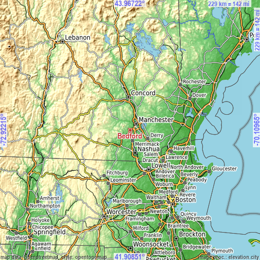
| \ | Map #1 | Map #2 | Topo.Map |
| Scale [m] | 38..205 m | 31..402 m | × |
| Scale [ft] | 125..673 ft | 102..1319 ft | × |
| Average | 100.5 m = 330 ft | 106.2 m = 348 ft | × |
| Width | 7.15 km = 4.4 mi | 14.31 km = 8.9 mi | 228.9 km = 142.2 mi |
| Height | 7.15 km = 4.4 mi | 14.31 km = 8.9 mi | 228.9 km = 142.2 mi |
| ↑Max Latitude | 42.978629° | 43.010771° | 43.96722° |
| Latitude at center | 42.94647° | 42.94647° | 42.94647° |
| ↓Min Latitude | 42.914294° | 42.882101° | 41.90851° |
| ← Min Longitude | -71.559845° | -71.603791° | -72.92215° |
| Longitude center | -71.5159° | -71.5159° | -71.5159° |
| →Max Longitude | -71.471955° | -71.428009° | -70.10965° |
Nearby cities:
Cities around Bedford sort by population:
• Manchester elevation 81 m
7.4 km,  42°
42°
• Merrimack 52 m
9.2 km,  168°
168°
• Londonderry 128 m
14.7 km,  128°
128°
• Milford 83 m
16.4 km,  221°
221°
• Litchfield 45 m
11.7 km, 165°
• South Hooksett 135 m
11 km, 36°
• Auburn 81 m
15.1 km,  64°
64°
• New Boston 151 m
14.9 km,  282°
282°
• Pinardville 85 m
5.4 km,  7°
7°
• East Merrimack 35 m
9.1 km,  163°
163°
• Goffstown 97 m
10.7 km,  320°
320°
• Mont Vernon 251 m
14.1 km,  245°
245°
Multilingual:
 En español:
Bedford elevación 96 m.
 En France:
Bedford élévation 96 m.


Sources and notes:
- [note 1] Map square and city borders are not equal. Map elevation data is calculated only from area inside that square.
- [src 1] Elevation data from geonames database provided with same terms of usage.
- [src 2] The elevation map of Bedford is generated using elevation data from NASA's 3 arcsec (90m) resolution SRTM data.
- [src 3] Base (background) map © OpenStreetMap contributors tiles are generated by Geofabrik and OpenTopoMap.
Copyright & License:
This Bedford Elevation Map is licensed under CC BY-SA. You may reuse any part from this page, if you give a proper credit by linking to this URL:
 More info on terms of use page.