Milford elevation
Milford (New Hampshire, Hillsborough County), United States elevation is 83 meters and Milford elevation in feet is 272 ft above sea level [src 1]. Milford is a populated place (feature code) with elevation that is 196 meters (643 ft) smaller than average city elevation in United States.
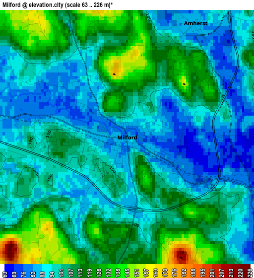
Below is the Elevation map of Milford, which displays elevation range with different colors. Scale of the first map is from 63 to 226 m (207 to 741 ft) with average elevation of 103.5 meters (=340 ft) [note 1]
These maps also provides idea of topography and contour of this city, they are displayed at different zoom levels. More info about maps, scale and edge coordinates you can find below images.
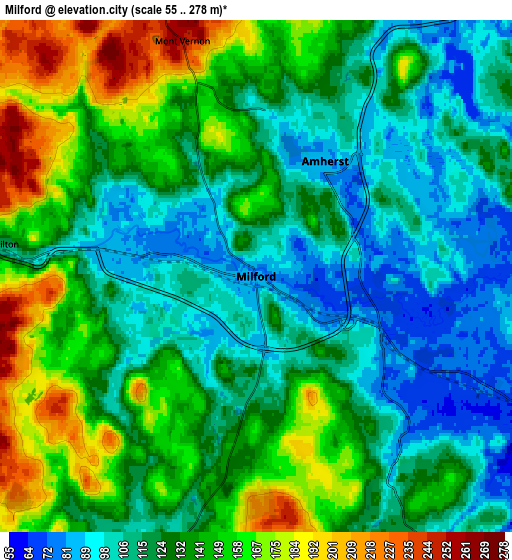
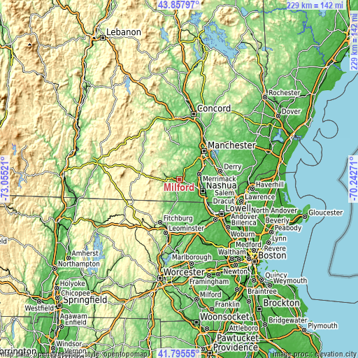
| \ | Map #1 | Map #2 | Topo.Map |
| Scale [m] | 63..226 m | 55..278 m | × |
| Scale [ft] | 207..741 ft | 180..912 ft | × |
| Average | 103.5 m = 340 ft | 130.4 m = 428 ft | × |
| Width | 7.17 km = 4.5 mi | 14.33 km = 8.9 mi | 229.3 km = 142.5 mi |
| Height | 7.17 km = 4.5 mi | 14.33 km = 8.9 mi | 229.3 km = 142.5 mi |
| ↑Max Latitude | 42.867577° | 42.899777° | 43.85797° |
| Latitude at center | 42.83536° | 42.83536° | 42.83536° |
| ↓Min Latitude | 42.803126° | 42.770875° | 41.79555° |
| ← Min Longitude | -71.692905° | -71.736851° | -73.05521° |
| Longitude center | -71.64896° | -71.64896° | -71.64896° |
| →Max Longitude | -71.605015° | -71.561069° | -70.24271° |
Nearby cities:
Cities around Milford sort by population:
• Merrimack elevation 52 m
13.1 km,  75°
75°
• Bedford 96 m
16.4 km,  41°
41°
• Litchfield 45 m
13.8 km,  85°
85°
• Hollis 128 m
11.3 km,  155°
155°
• New Boston 151 m
16.1 km,  346°
346°
• Brookline 86 m
11.2 km,  183°
183°
• East Merrimack 35 m
14 km,  74°
74°
• Mont Vernon 251 m
6.9 km,  342°
342°
• Lyndeborough 270 m
12.5 km,  309°
309°
• Mason 231 m
14.1 km,  223°
223°
• Wilton 121 m
7.1 km,  277°
277°
• Greenville 255 m
15.3 km,  240°
240°
Multilingual:
 En español:
Milford elevación 83 m.
 En France:
Milford élévation 83 m.


Sources and notes:
- [note 1] Map square and city borders are not equal. Map elevation data is calculated only from area inside that square.
- [src 1] Elevation data from geonames database provided with same terms of usage.
- [src 2] The elevation map of Milford is generated using elevation data from NASA's 3 arcsec (90m) resolution SRTM data.
- [src 3] Base (background) map © OpenStreetMap contributors tiles are generated by Geofabrik and OpenTopoMap.
Copyright & License:
This Milford Elevation Map is licensed under CC BY-SA. You may reuse any part from this page, if you give a proper credit by linking to this URL:
 More info on terms of use page.