Taylor elevation
Taylor (Nebraska, Loup County), United States elevation is 696 meters and Taylor elevation in feet is 2283 ft above sea level [src 1]. Taylor is a seat of a second-order administrative division (feature code) with elevation that is 417 meters (1368 ft) bigger than average city elevation in United States.
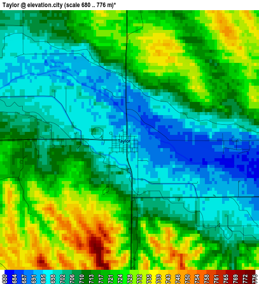
Below is the Elevation map of Taylor, which displays elevation range with different colors. Scale of the first map is from 680 to 776 m (2231 to 2546 ft) with average elevation of 713.1 meters (=2340 ft) [note 1]
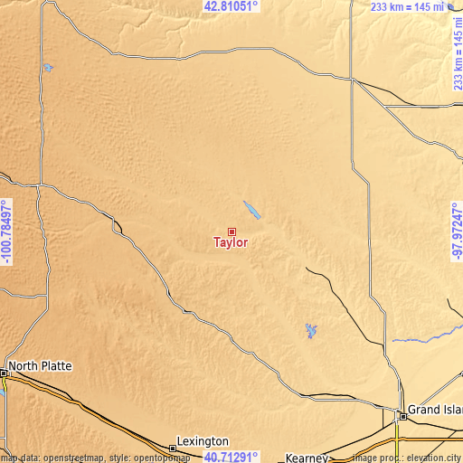
These maps also provides idea of topography and contour of this city, they are displayed at different zoom levels. More info about maps, scale and edge coordinates you can find below images.
| \ | Map #1 | Topo.Map |
| Scale [m] | 680..776 m | × |
| Scale [ft] | 2231..2546 ft | × |
| Average | 713.1 m = 2340 ft | × |
| Width | 7.29 km = 4.5 mi | 233.2 km = 144.9 mi |
| Height | 7.29 km = 4.5 mi | 233.2 km = 144.9 mi |
| ↑Max Latitude | 41.803047° | 42.81051° |
| Latitude at center | 41.77028° | 41.77028° |
| ↓Min Latitude | 41.737496° | 40.71291° |
| ← Min Longitude | -99.422665° | -100.78497° |
| Longitude center | -99.37872° | -99.37872° |
| →Max Longitude | -99.334775° | -97.97247° |
Nearby cities:
Cities around Taylor sort by population:
• O'Neill elevation 608 m
97.4 km,  38°
38°
• Broken Bow 757 m
46.3 km,  207°
207°
• Ord 628 m
41.9 km,  116°
116°
• Ainsworth 771 m
95.4 km,  335°
335°
• Ravenna 614 m
91.4 km,  154°
154°
• Atkinson 643 m
90.8 km,  21°
21°
• Burwell 664 m
20.4 km,  86°
86°
• Loup City 637 m
64.8 km, 148°
• Bassett 709 m
91.6 km,  351°
351°
• Greeley 618 m
74.6 km,  109°
109°
• Bartlett 669 m
69.7 km,  79°
79°
• Brewster 763 m
44.4 km,  294°
294°
Multilingual:
 En español:
Taylor elevación 696 m.
 En France:
Taylor élévation 696 m.


Sources and notes:
- [note 1] Map square and city borders are not equal. Map elevation data is calculated only from area inside that square.
- [src 1] Elevation data from geonames database provided with same terms of usage.
- [src 2] The elevation map of Taylor is generated using elevation data from NASA's 3 arcsec (90m) resolution SRTM data.
- [src 3] Base (background) map © OpenStreetMap contributors tiles are generated by Geofabrik and OpenTopoMap.
Copyright & License:
This Taylor Elevation Map is licensed under CC BY-SA. You may reuse any part from this page, if you give a proper credit by linking to this URL:
 More info on terms of use page.