Ainsworth elevation
Ainsworth (Nebraska, Brown County), United States elevation is 771 meters and Ainsworth elevation in feet is 2530 ft above sea level [src 1]. Ainsworth is a seat of a second-order administrative division (feature code) with elevation that is 492 meters (1614 ft) bigger than average city elevation in United States.
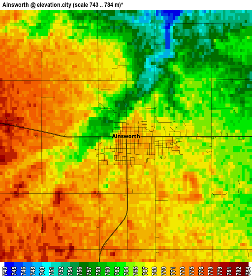
Below is the Elevation map of Ainsworth, which displays elevation range with different colors. Scale of the first map is from 743 to 784 m (2438 to 2572 ft) with average elevation of 767.1 meters (=2517 ft) [note 1]
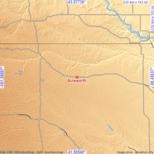
These maps also provides idea of topography and contour of this city, they are displayed at different zoom levels. More info about maps, scale and edge coordinates you can find below images.
| \ | Map #1 | Topo.Map |
| Scale [m] | 743..784 m | × |
| Scale [ft] | 2438..2572 ft | × |
| Average | 767.1 m = 2517 ft | × |
| Width | 7.2 km = 4.5 mi | 230.4 km = 143.2 mi |
| Height | 7.2 km = 4.5 mi | 230.4 km = 143.2 mi |
| ↑Max Latitude | 42.582366° | 43.57736° |
| Latitude at center | 42.55° | 42.55° |
| ↓Min Latitude | 42.517618° | 41.50545° |
| ← Min Longitude | -99.906565° | -101.26887° |
| Longitude center | -99.86262° | -99.86262° |
| →Max Longitude | -99.818675° | -98.45637° |
Nearby cities:
Cities around Ainsworth sort by population:
• O'Neill elevation 608 m
100.1 km,  95°
95°
• Valentine 788 m
66.7 km,  302°
302°
• Winner 599 m
91.9 km,  0°
0°
• Gregory 660 m
83.6 km,  24°
24°
• Atkinson 643 m
72.5 km,  91°
91°
• Burke 668 m
84.3 km,  33°
33°
• Bassett 709 m
26.9 km,  81°
81°
• Butte 552 m
92 km,  64°
64°
• Springview 747 m
31.9 km, 16°
• Thedford 871 m
86.5 km,  222°
222°
• Taylor 696 m
95.4 km,  155°
155°
• Brewster 763 m
67.9 km,  180°
180°
Multilingual:
 En español:
Ainsworth elevación 771 m.
 En France:
Ainsworth élévation 771 m.
 Auf Deutsch:
Ainsworth höhe über dem Meeresspiegel ist 771 m.

Sources and notes:
- [note 1] Map square and city borders are not equal. Map elevation data is calculated only from area inside that square.
- [src 1] Elevation data from geonames database provided with same terms of usage.
- [src 2] The elevation map of Ainsworth is generated using elevation data from NASA's 3 arcsec (90m) resolution SRTM data.
- [src 3] Base (background) map © OpenStreetMap contributors tiles are generated by Geofabrik and OpenTopoMap.
Copyright & License:
This Ainsworth Elevation Map is licensed under CC BY-SA. You may reuse any part from this page, if you give a proper credit by linking to this URL:
 More info on terms of use page.