Ravenna elevation
Ravenna (Nebraska, Buffalo County), United States elevation is 614 meters and Ravenna elevation in feet is 2014 ft above sea level [src 1]. Ravenna is a populated place (feature code) with elevation that is 335 meters (1099 ft) bigger than average city elevation in United States.
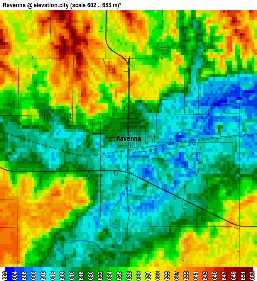
Below is the Elevation map of Ravenna, which displays elevation range with different colors. Scale of the first map is from 602 to 653 m (1975 to 2142 ft) with average elevation of 623.8 meters (=2047 ft) [note 1]
These maps also provides idea of topography and contour of this city, they are displayed at different zoom levels. More info about maps, scale and edge coordinates you can find below images.
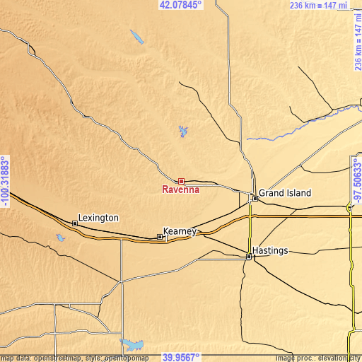
| \ | Map #1 | Topo.Map |
| Scale [m] | 602..653 m | × |
| Scale [ft] | 1975..2142 ft | × |
| Average | 623.8 m = 2047 ft | × |
| Width | 7.37 km = 4.6 mi | 235.9 km = 146.6 mi |
| Height | 7.37 km = 4.6 mi | 235.9 km = 146.6 mi |
| ↑Max Latitude | 41.059264° | 42.07845° |
| Latitude at center | 41.02612° | 41.02612° |
| ↓Min Latitude | 40.992959° | 39.9567° |
| ← Min Longitude | -98.956525° | -100.31883° |
| Longitude center | -98.91258° | -98.91258° |
| →Max Longitude | -98.868635° | -97.50633° |
Nearby cities:
Cities around Ravenna sort by population:
• Grand Island elevation 573 m
49.2 km,  103°
103°
• Kearney 662 m
39 km,  201°
201°
• Hastings 590 m
65.9 km,  137°
137°
• Broken Bow 757 m
73.8 km,  304°
304°
• Minden 667 m
58.7 km,  182°
182°
• Saint Paul 555 m
43.5 km,  61°
61°
• Ord 628 m
64.2 km,  358°
358°
• Gibbon 631 m
31.4 km,  169°
169°
• Wood River 601 m
34.8 km,  131°
131°
• Shelton 619 m
31.4 km,  150°
150°
• Loup City 637 m
28.1 km,  350°
350°
• Greeley 618 m
66.3 km,  28°
28°
Multilingual:
 En español:
Ravenna elevación 614 m.
 En France:
Ravenna élévation 614 m.


Sources and notes:
- [note 1] Map square and city borders are not equal. Map elevation data is calculated only from area inside that square.
- [src 1] Elevation data from geonames database provided with same terms of usage.
- [src 2] The elevation map of Ravenna is generated using elevation data from NASA's 3 arcsec (90m) resolution SRTM data.
- [src 3] Base (background) map © OpenStreetMap contributors tiles are generated by Geofabrik and OpenTopoMap.
Copyright & License:
This Ravenna Elevation Map is licensed under CC BY-SA. You may reuse any part from this page, if you give a proper credit by linking to this URL:
 More info on terms of use page.