Grand Island elevation
Grand Island (Nebraska, Hall County), United States elevation is 573 meters and Grand Island elevation in feet is 1880 ft above sea level [src 1]. Grand Island is a seat of a second-order administrative division (feature code) with elevation that is 294 meters (965 ft) bigger than average city elevation in United States.
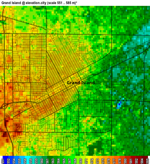
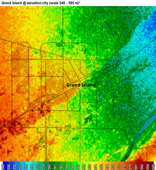
Below is the Elevation map of Grand Island, which displays elevation range with different colors. Scale of the first map is from 551 to 585 m (1808 to 1919 ft) with average elevation of 568.2 meters (=1864 ft) [note 1]
These maps also provides idea of topography and contour of this city, they are displayed at different zoom levels. More info about maps, scale and edge coordinates you can find below images.
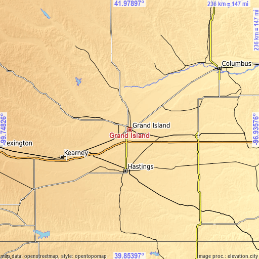
| \ | Map #1 | Map #2 | Topo.Map |
| Scale [m] | 551..585 m | 549..585 m | × |
| Scale [ft] | 1808..1919 ft | 1801..1919 ft | × |
| Average | 568.2 m = 1864 ft | 567.5 m = 1862 ft | × |
| Width | 7.38 km = 4.6 mi | 14.77 km = 9.2 mi | 236.3 km = 146.8 mi |
| Height | 7.38 km = 4.6 mi | 14.77 km = 9.2 mi | 236.3 km = 146.8 mi |
| ↑Max Latitude | 40.958205° | 40.991384° | 41.97897° |
| Latitude at center | 40.92501° | 40.92501° | 40.92501° |
| ↓Min Latitude | 40.891798° | 40.858569° | 39.85397° |
| ← Min Longitude | -98.385955° | -98.429901° | -99.74826° |
| Longitude center | -98.34201° | -98.34201° | -98.34201° |
| →Max Longitude | -98.298065° | -98.254119° | -96.93576° |
Nearby cities:
Cities around Grand Island sort by population:
• Hastings elevation 590 m
37.9 km,  185°
185°
• York 490 m
63.4 km,  95°
95°
• Aurora 547 m
29.1 km, 102°
• Central City 519 m
35.6 km,  53°
53°
• Saint Paul 555 m
33.7 km,  343°
343°
• Gibbon 631 m
46.6 km,  245°
245°
• Sutton 513 m
54 km,  131°
131°
• Ravenna 614 m
49.2 km,  283°
283°
• Wood River 601 m
24.6 km,  241°
241°
• Fullerton 504 m
57.9 km,  32°
32°
• Shelton 619 m
36.5 km, 243°
• Clay Center 549 m
50.9 km,  151°
151°
Multilingual:
 En español:
Grand Island elevación 573 m.
 En France:
Grand Island élévation 573 m.
 Auf Deutsch:
Grand Island höhe über dem Meeresspiegel ist 573 m.

Sources and notes:
- [note 1] Map square and city borders are not equal. Map elevation data is calculated only from area inside that square.
- [src 1] Elevation data from geonames database provided with same terms of usage.
- [src 2] The elevation map of Grand Island is generated using elevation data from NASA's 3 arcsec (90m) resolution SRTM data.
- [src 3] Base (background) map © OpenStreetMap contributors tiles are generated by Geofabrik and OpenTopoMap.
Copyright & License:
This Grand Island Elevation Map is licensed under CC BY-SA. You may reuse any part from this page, if you give a proper credit by linking to this URL:
 More info on terms of use page.