Thief River Falls elevation
Thief River Falls (Minnesota, Pennington County), United States elevation is 345 meters and Thief River Falls elevation in feet is 1132 ft above sea level [src 1]. Thief River Falls is a seat of a second-order administrative division (feature code) with elevation that is 66 meters (217 ft) bigger than average city elevation in United States.
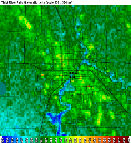
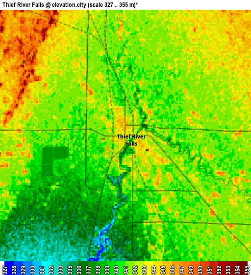
Below is the Elevation map of Thief River Falls, which displays elevation range with different colors. Scale of the first map is from 333 to 354 m (1093 to 1161 ft) with average elevation of 341.2 meters (=1119 ft) [note 1]
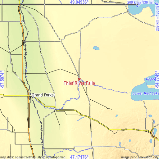
These maps also provides idea of topography and contour of this city, they are displayed at different zoom levels. More info about maps, scale and edge coordinates you can find below images.
| \ | Map #1 | Map #2 | Topo.Map |
| Scale [m] | 333..354 m | 327..355 m | × |
| Scale [ft] | 1093..1161 ft | 1073..1165 ft | × |
| Average | 341.2 m = 1119 ft | 341.4 m = 1120 ft | × |
| Width | 6.52 km = 4.1 mi | 13.05 km = 8.1 mi | 208.8 km = 129.7 mi |
| Height | 6.52 km = 4.1 mi | 13.05 km = 8.1 mi | 208.8 km = 129.7 mi |
| ↑Max Latitude | 48.148469° | 48.177781° | 49.04936° |
| Latitude at center | 48.11914° | 48.11914° | 48.11914° |
| ↓Min Latitude | 48.089794° | 48.060432° | 47.17176° |
| ← Min Longitude | -96.225095° | -96.269041° | -97.5874° |
| Longitude center | -96.18115° | -96.18115° | -96.18115° |
| →Max Longitude | -96.137205° | -96.093259° | -94.7749° |
Nearby cities:
Cities around Thief River Falls sort by population:
• Grand Forks elevation 256 m
66.9 km,  251°
251°
• East Grand Forks 254 m
66.1 km, 251°
• Crookston 266 m
49.8 km,  219°
219°
• Roseau 318 m
86.5 km,  20°
20°
• Red Lake 371 m
90.7 km,  107°
107°
• Warren 260 m
44.7 km,  281°
281°
• Fosston 393 m
68.3 km,  152°
152°
• Red Lake Falls 311 m
27.2 km,  194°
194°
• Bagley 440 m
88.5 km,  138°
138°
• Mahnomen 368 m
90.8 km,  169°
169°
• Little Rock 368 m
84.4 km, 109°
• Thompson 264 m
79.1 km,  240°
240°
Multilingual:
 En español:
Thief River Falls elevación 345 m.
 En France:
Thief River Falls élévation 345 m.
 Auf Deutsch:
Thief River Falls höhe über dem Meeresspiegel ist 345 m.

Sources and notes:
- [note 1] Map square and city borders are not equal. Map elevation data is calculated only from area inside that square.
- [src 1] Elevation data from geonames database provided with same terms of usage.
- [src 2] The elevation map of Thief River Falls is generated using elevation data from NASA's 3 arcsec (90m) resolution SRTM data.
- [src 3] Base (background) map © OpenStreetMap contributors tiles are generated by Geofabrik and OpenTopoMap.
Copyright & License:
This Thief River Falls Elevation Map is licensed under CC BY-SA. You may reuse any part from this page, if you give a proper credit by linking to this URL:
 More info on terms of use page.