East Grand Forks elevation
East Grand Forks (Minnesota, Polk County), United States elevation is 254 meters and East Grand Forks elevation in feet is 833 ft above sea level [src 1]. East Grand Forks is a populated place (feature code) with elevation that is 25 meters (82 ft) smaller than average city elevation in United States.
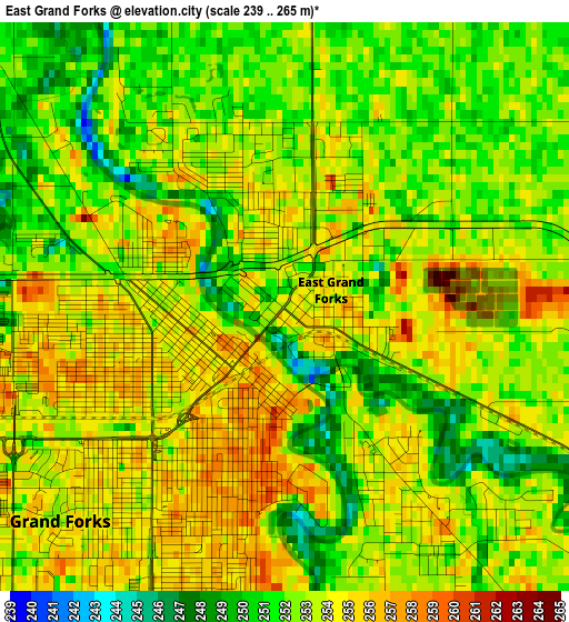
Below is the Elevation map of East Grand Forks, which displays elevation range with different colors. Scale of the first map is from 239 to 265 m (784 to 869 ft) with average elevation of 252.7 meters (=829 ft) [note 1]
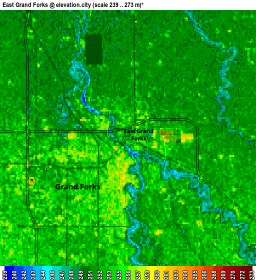
These maps also provides idea of topography and contour of this city, they are displayed at different zoom levels. More info about maps, scale and edge coordinates you can find below images.
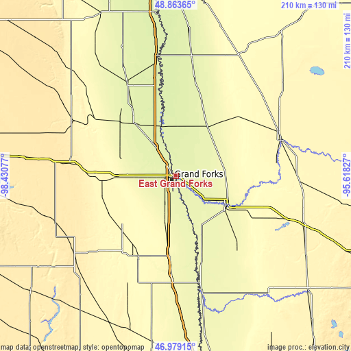
| \ | Map #1 | Map #2 | Topo.Map |
| Scale [m] | 239..265 m | 239..273 m | × |
| Scale [ft] | 784..869 ft | 784..896 ft | × |
| Average | 252.7 m = 829 ft | 252.2 m = 827 ft | × |
| Width | 6.55 km = 4.1 mi | 13.1 km = 8.1 mi | 209.5 km = 130.2 mi |
| Height | 6.55 km = 4.1 mi | 13.1 km = 8.1 mi | 209.5 km = 130.2 mi |
| ↑Max Latitude | 47.959417° | 47.988837° | 48.86365° |
| Latitude at center | 47.92998° | 47.92998° | 47.92998° |
| ↓Min Latitude | 47.900527° | 47.871056° | 46.97915° |
| ← Min Longitude | -97.068465° | -97.112411° | -98.43077° |
| Longitude center | -97.02452° | -97.02452° | -97.02452° |
| →Max Longitude | -96.980575° | -96.936629° | -95.61827° |
Nearby cities:
Cities around East Grand Forks sort by population:
• Grand Forks elevation 256 m
0.8 km,  229°
229°
• Thief River Falls 345 m
66.1 km,  71°
71°
• Crookston 266 m
35.6 km,  119°
119°
• Grafton 252 m
60.8 km,  331°
331°
• Grand Forks Air Force Base 271 m
27.1 km,  275°
275°
• Mayville 300 m
53 km,  205°
205°
• Hillsboro 277 m
58.6 km,  182°
182°
• Warren 260 m
35.1 km,  32°
32°
• Red Lake Falls 311 m
56.2 km,  95°
95°
• Park River 301 m
74.4 km,  314°
314°
• Larimore 347 m
45 km,  266°
266°
• Thompson 264 m
18.5 km,  200°
200°
Multilingual:
 En español:
East Grand Forks elevación 254 m.
 En France:
East Grand Forks élévation 254 m.
 Auf Deutsch:
East Grand Forks höhe über dem Meeresspiegel ist 254 m.

Sources and notes:
- [note 1] Map square and city borders are not equal. Map elevation data is calculated only from area inside that square.
- [src 1] Elevation data from geonames database provided with same terms of usage.
- [src 2] The elevation map of East Grand Forks is generated using elevation data from NASA's 3 arcsec (90m) resolution SRTM data.
- [src 3] Base (background) map © OpenStreetMap contributors tiles are generated by Geofabrik and OpenTopoMap.
Copyright & License:
This East Grand Forks Elevation Map is licensed under CC BY-SA. You may reuse any part from this page, if you give a proper credit by linking to this URL:
 More info on terms of use page.