Mahnomen elevation
Mahnomen (Minnesota, Mahnomen County), United States elevation is 368 meters and Mahnomen elevation in feet is 1207 ft above sea level [src 1]. Mahnomen is a seat of a second-order administrative division (feature code) with elevation that is 89 meters (292 ft) bigger than average city elevation in United States.
Below is the Elevation map of Mahnomen, which displays elevation range with different colors. Scale of the first map is from 355 to 378 m (1165 to 1240 ft) with average elevation of 367.2 meters (=1205 ft) [note 1]
These maps also provides idea of topography and contour of this city, they are displayed at different zoom levels. More info about maps, scale and edge coordinates you can find below images.
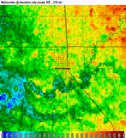
| \ | Map #1 | Topo.Map |
| Scale [m] | 355..378 m | × |
| Scale [ft] | 1165..1240 ft | × |
| Average | 367.2 m = 1205 ft | × |
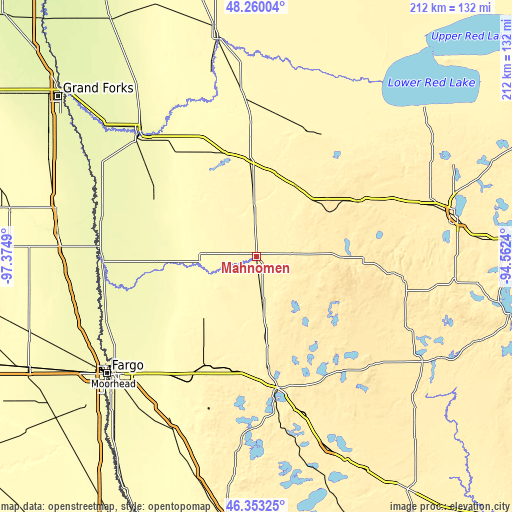
| Width | 6.63 km = 4.1 mi | 212 km = 131.7 mi |
| Height | 6.63 km = 4.1 mi | 212 km = 131.7 mi |
| ↑Max Latitude | 47.345025° | 48.26004° |
| Latitude at center | 47.31524° | 47.31524° |
| ↓Min Latitude | 47.285438° | 46.35325° |
| ← Min Longitude | -96.012595° | -97.3749° |
| Longitude center | -95.96865° | -95.96865° |
| →Max Longitude | -95.924705° | -94.5624° |
Nearby cities:
Cities around Mahnomen sort by population:
• Moorhead elevation 273 m
78 km,  231°
231°
• Detroit Lakes 418 m
56.2 km,  170°
170°
• Crookston 266 m
70.1 km,  316°
316°
• Dilworth 277 m
74 km, 228°
• Hawley 350 m
55 km,  208°
208°
• Ada 276 m
41.3 km,  267°
267°
• Fosston 393 m
33.3 km,  29°
29°
• Red Lake Falls 311 m
67.1 km,  340°
340°
• Bagley 440 m
48.7 km,  61°
61°
• Oakport 273 m
74.7 km,  235°
235°
• Glyndon 284 m
67.3 km,  223°
223°
• Frazee 423 m
68.4 km,  162°
162°
Multilingual:
 En español:
Mahnomen elevación 368 m.
 En France:
Mahnomen élévation 368 m.
 Auf Deutsch:
Mahnomen höhe über dem Meeresspiegel ist 368 m.

Sources and notes:
- [note 1] Map square and city borders are not equal. Map elevation data is calculated only from area inside that square.
- [src 1] Elevation data from geonames database provided with same terms of usage.
- [src 2] The elevation map of Mahnomen is generated using elevation data from NASA's 3 arcsec (90m) resolution SRTM data.
- [src 3] Base (background) map © OpenStreetMap contributors tiles are generated by Geofabrik and OpenTopoMap.
Copyright & License:
This Mahnomen Elevation Map is licensed under CC BY-SA. You may reuse any part from this page, if you give a proper credit by linking to this URL:
 More info on terms of use page.