Spring Valley elevation
Spring Valley (Minnesota, Fillmore County), United States elevation is 388 meters and Spring Valley elevation in feet is 1273 ft above sea level [src 1]. Spring Valley is a populated place (feature code) with elevation that is 109 meters (358 ft) bigger than average city elevation in United States.
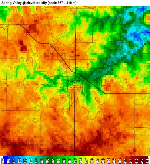
Below is the Elevation map of Spring Valley, which displays elevation range with different colors. Scale of the first map is from 367 to 419 m (1204 to 1375 ft) with average elevation of 399.7 meters (=1311 ft) [note 1]
These maps also provides idea of topography and contour of this city, they are displayed at different zoom levels. More info about maps, scale and edge coordinates you can find below images.
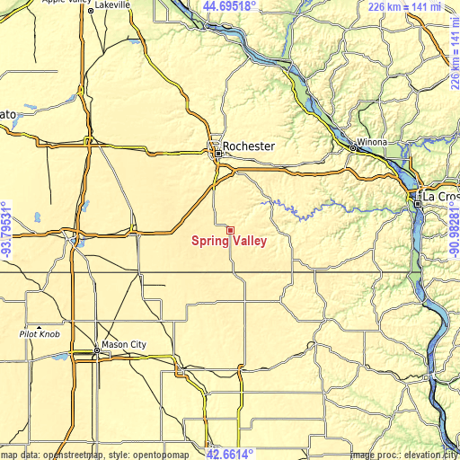
| \ | Map #1 | Topo.Map |
| Scale [m] | 367..419 m | × |
| Scale [ft] | 1204..1375 ft | × |
| Average | 399.7 m = 1311 ft | × |
| Width | 7.07 km = 4.4 mi | 226.1 km = 140.5 mi |
| Height | 7.07 km = 4.4 mi | 226.1 km = 140.5 mi |
| ↑Max Latitude | 43.71868° | 44.69518° |
| Latitude at center | 43.68691° | 43.68691° |
| ↓Min Latitude | 43.655124° | 42.6614° |
| ← Min Longitude | -92.433005° | -93.79531° |
| Longitude center | -92.38906° | -92.38906° |
| →Max Longitude | -92.345115° | -90.98281° |
Nearby cities:
Cities around Spring Valley sort by population:
• Rochester elevation 314 m
37.8 km,  350°
350°
• Austin 370 m
47.1 km,  267°
267°
• Kasson 383 m
47.9 km,  322°
322°
• Stewartville 374 m
20.4 km,  336°
336°
• Byron 384 m
43.6 km,  331°
331°
• Cresco 396 m
40.6 km,  146°
146°
• Saint Charles 345 m
40.8 km,  39°
39°
• Chatfield 308 m
23.9 km, 42°
• Eyota 377 m
35.9 km,  21°
21°
• Hayfield 401 m
43.2 km,  301°
301°
• Preston 291 m
24.7 km,  94°
94°
• Grand Meadow 413 m
14.9 km,  278°
278°
Multilingual:
 En español:
Spring Valley elevación 388 m.
 En France:
Spring Valley élévation 388 m.
 Auf Deutsch:
Spring Valley höhe über dem Meeresspiegel ist 388 m.

Sources and notes:
- [note 1] Map square and city borders are not equal. Map elevation data is calculated only from area inside that square.
- [src 1] Elevation data from geonames database provided with same terms of usage.
- [src 2] The elevation map of Spring Valley is generated using elevation data from NASA's 3 arcsec (90m) resolution SRTM data.
- [src 3] Base (background) map © OpenStreetMap contributors tiles are generated by Geofabrik and OpenTopoMap.
Copyright & License:
This Spring Valley Elevation Map is licensed under CC BY-SA. You may reuse any part from this page, if you give a proper credit by linking to this URL:
 More info on terms of use page.