Preston elevation
Preston (Minnesota, Fillmore County), United States elevation is 291 meters and Preston elevation in feet is 955 ft above sea level [src 1]. Preston is a seat of a second-order administrative division (feature code) with elevation that is 12 meters (39 ft) bigger than average city elevation in United States.
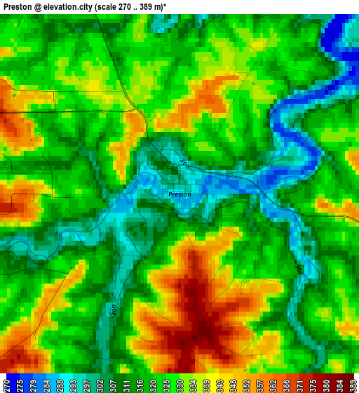
Below is the Elevation map of Preston, which displays elevation range with different colors. Scale of the first map is from 270 to 389 m (886 to 1276 ft) with average elevation of 323.3 meters (=1061 ft) [note 1]
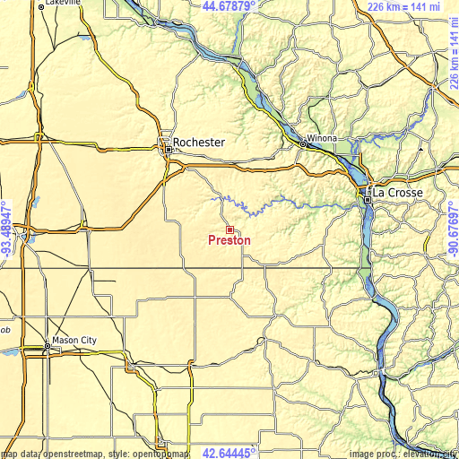
These maps also provides idea of topography and contour of this city, they are displayed at different zoom levels. More info about maps, scale and edge coordinates you can find below images.
| \ | Map #1 | Topo.Map |
| Scale [m] | 270..389 m | × |
| Scale [ft] | 886..1276 ft | × |
| Average | 323.3 m = 1061 ft | × |
| Width | 7.07 km = 4.4 mi | 226.2 km = 140.6 mi |
| Height | 7.07 km = 4.4 mi | 226.2 km = 140.6 mi |
| ↑Max Latitude | 43.702018° | 44.67879° |
| Latitude at center | 43.67024° | 43.67024° |
| ↓Min Latitude | 43.638445° | 42.64445° |
| ← Min Longitude | -92.127165° | -93.48947° |
| Longitude center | -92.08322° | -92.08322° |
| →Max Longitude | -92.039275° | -90.67697° |
Nearby cities:
Cities around Preston sort by population:
• Decorah elevation 271 m
47.3 km,  149°
149°
• Stewartville 374 m
38.5 km,  302°
302°
• Cresco 396 m
32.2 km,  184°
184°
• Saint Charles 345 m
33.3 km,  2°
2°
• Chatfield 308 m
21.3 km,  336°
336°
• Caledonia 364 m
47.3 km,  94°
94°
• Spring Valley 388 m
24.7 km,  274°
274°
• Eyota 377 m
37.2 km, 341°
• Rushford 219 m
30.7 km,  59°
59°
• Lewiston 369 m
38.9 km,  26°
26°
• Spring Grove 404 m
38 km,  108°
108°
• Grand Meadow 413 m
39.5 km,  275°
275°
Multilingual:
 En español:
Preston elevación 291 m.
 En France:
Preston élévation 291 m.


Sources and notes:
- [note 1] Map square and city borders are not equal. Map elevation data is calculated only from area inside that square.
- [src 1] Elevation data from geonames database provided with same terms of usage.
- [src 2] The elevation map of Preston is generated using elevation data from NASA's 3 arcsec (90m) resolution SRTM data.
- [src 3] Base (background) map © OpenStreetMap contributors tiles are generated by Geofabrik and OpenTopoMap.
Copyright & License:
This Preston Elevation Map is licensed under CC BY-SA. You may reuse any part from this page, if you give a proper credit by linking to this URL:
 More info on terms of use page.