Redby elevation
Redby (Minnesota, Beltrami County), United States elevation is 369 meters and Redby elevation in feet is 1211 ft above sea level [src 1]. Redby is a populated place (feature code) with elevation that is 90 meters (295 ft) bigger than average city elevation in United States.
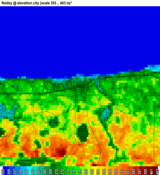
Below is the Elevation map of Redby, which displays elevation range with different colors. Scale of the first map is from 353 to 403 m (1158 to 1322 ft) with average elevation of 367.7 meters (=1206 ft) [note 1]
These maps also provides idea of topography and contour of this city, they are displayed at different zoom levels. More info about maps, scale and edge coordinates you can find below images.
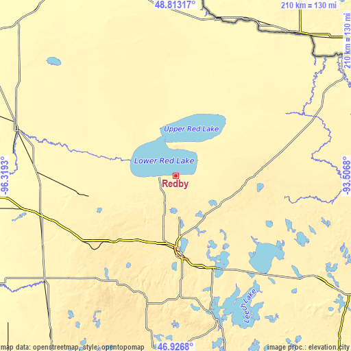
| \ | Map #1 | Topo.Map |
| Scale [m] | 353..403 m | × |
| Scale [ft] | 1158..1322 ft | × |
| Average | 367.7 m = 1206 ft | × |
| Width | 6.55 km = 4.1 mi | 209.7 km = 130.3 mi |
| Height | 6.55 km = 4.1 mi | 209.7 km = 130.3 mi |
| ↑Max Latitude | 47.908036° | 48.81317° |
| Latitude at center | 47.87857° | 47.87857° |
| ↓Min Latitude | 47.849087° | 46.9268° |
| ← Min Longitude | -94.956995° | -96.3193° |
| Longitude center | -94.91305° | -94.91305° |
| →Max Longitude | -94.869105° | -93.5068° |
Nearby cities:
Cities around Redby sort by population:
• Bemidji elevation 416 m
45.1 km,  176°
176°
• Thief River Falls 345 m
98.1 km,  285°
285°
• Park Rapids 437 m
106.9 km,  185°
185°
• Warroad 325 m
117.9 km,  345°
345°
• Red Lake 371 m
7.8 km,  268°
268°
• Fosston 393 m
71.1 km,  241°
241°
• Red Lake Falls 311 m
101.5 km, 270°
• Bagley 440 m
53.8 km,  222°
222°
• Mahnomen 368 m
100.9 km,  231°
231°
• Little Rock 368 m
14.8 km, 265°
• Baudette 329 m
95.6 km,  14°
14°
• Walker 402 m
89.8 km,  164°
164°
Multilingual:
 En español:
Redby elevación 369 m.
 En France:
Redby élévation 369 m.


Sources and notes:
- [note 1] Map square and city borders are not equal. Map elevation data is calculated only from area inside that square.
- [src 1] Elevation data from geonames database provided with same terms of usage.
- [src 2] The elevation map of Redby is generated using elevation data from NASA's 3 arcsec (90m) resolution SRTM data.
- [src 3] Base (background) map © OpenStreetMap contributors tiles are generated by Geofabrik and OpenTopoMap.
Copyright & License:
This Redby Elevation Map is licensed under CC BY-SA. You may reuse any part from this page, if you give a proper credit by linking to this URL:
 More info on terms of use page.