Hinckley elevation
Hinckley (Minnesota, Pine County), United States elevation is 312 meters and Hinckley elevation in feet is 1024 ft above sea level [src 1]. Hinckley is a populated place (feature code) with elevation that is 33 meters (108 ft) bigger than average city elevation in United States.
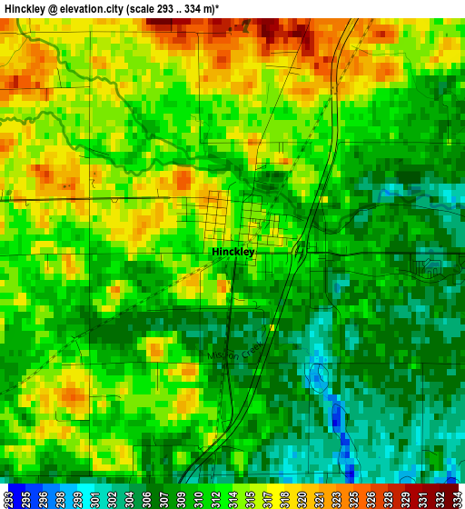
Below is the Elevation map of Hinckley, which displays elevation range with different colors. Scale of the first map is from 293 to 334 m (961 to 1096 ft) with average elevation of 311.9 meters (=1023 ft) [note 1]
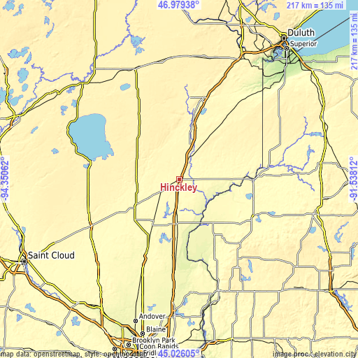
These maps also provides idea of topography and contour of this city, they are displayed at different zoom levels. More info about maps, scale and edge coordinates you can find below images.
| \ | Map #1 | Topo.Map |
| Scale [m] | 293..334 m | × |
| Scale [ft] | 961..1096 ft | × |
| Average | 311.9 m = 1023 ft | × |
| Width | 6.79 km = 4.2 mi | 217.2 km = 135 mi |
| Height | 6.79 km = 4.2 mi | 217.2 km = 135 mi |
| ↑Max Latitude | 46.041852° | 46.97938° |
| Latitude at center | 46.01134° | 46.01134° |
| ↓Min Latitude | 45.980811° | 45.02605° |
| ← Min Longitude | -92.988315° | -94.35062° |
| Longitude center | -92.94437° | -92.94437° |
| →Max Longitude | -92.900425° | -91.53812° |
Nearby cities:
Cities around Hinckley sort by population:
• Cambridge elevation 291 m
53.4 km,  203°
203°
• Mora 307 m
30.9 km,  241°
241°
• Pine City 285 m
20.7 km,  185°
185°
• Rush City 280 m
36.3 km,  182°
182°
• Sandstone 332 m
14.6 km,  24°
24°
• Moose Lake 323 m
51.2 km, 15°
• Braham 289 m
36.6 km,  208°
208°
• Rock Creek 284 m
28.3 km, 182°
• Grantsburg 288 m
33.1 km,  142°
142°
• Harris 273 m
47.3 km, 182°
• Frederic 368 m
53.9 km, 136°
• Siren 303 m
50.3 km,  119°
119°
Multilingual:
 En español:
Hinckley elevación 312 m.
 En France:
Hinckley élévation 312 m.
 Auf Deutsch:
Hinckley höhe über dem Meeresspiegel ist 312 m.

Sources and notes:
- [note 1] Map square and city borders are not equal. Map elevation data is calculated only from area inside that square.
- [src 1] Elevation data from geonames database provided with same terms of usage.
- [src 2] The elevation map of Hinckley is generated using elevation data from NASA's 3 arcsec (90m) resolution SRTM data.
- [src 3] Base (background) map © OpenStreetMap contributors tiles are generated by Geofabrik and OpenTopoMap.
Copyright & License:
This Hinckley Elevation Map is licensed under CC BY-SA. You may reuse any part from this page, if you give a proper credit by linking to this URL:
 More info on terms of use page.