Siren elevation
Siren (Wisconsin, Burnett County), United States elevation is 303 meters and Siren elevation in feet is 994 ft above sea level [src 1]. Siren is a seat of a second-order administrative division (feature code) with elevation that is 24 meters (79 ft) bigger than average city elevation in United States.
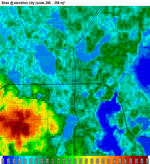
Below is the Elevation map of Siren, which displays elevation range with different colors. Scale of the first map is from 286 to 358 m (938 to 1175 ft) with average elevation of 305.8 meters (=1003 ft) [note 1]
These maps also provides idea of topography and contour of this city, they are displayed at different zoom levels. More info about maps, scale and edge coordinates you can find below images.
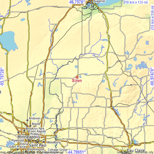
| \ | Map #1 | Topo.Map |
| Scale [m] | 286..358 m | × |
| Scale [ft] | 938..1175 ft | × |
| Average | 305.8 m = 1003 ft | × |
| Width | 6.81 km = 4.2 mi | 218.1 km = 135.5 mi |
| Height | 6.81 km = 4.2 mi | 218.1 km = 135.5 mi |
| ↑Max Latitude | 45.816417° | 46.7578° |
| Latitude at center | 45.78578° | 45.78578° |
| ↓Min Latitude | 45.755127° | 44.79651° |
| ← Min Longitude | -92.424975° | -93.78728° |
| Longitude center | -92.38103° | -92.38103° |
| →Max Longitude | -92.337085° | -90.97478° |
Nearby cities:
Cities around Siren sort by population:
• Pine City elevation 285 m
45.8 km,  275°
275°
• Rush City 280 m
46.7 km,  256°
256°
• Spooner 329 m
38.3 km,  83°
83°
• Cumberland 377 m
39.8 km,  135°
135°
• Saint Croix Falls 278 m
46.4 km,  205°
205°
• Rock Creek 284 m
45.2 km,  266°
266°
• Shell Lake 378 m
35.7 km,  98°
98°
• Grantsburg 288 m
23.4 km, 267°
• Frederic 368 m
15.6 km, 205°
• Luck 369 m
24.6 km,  198°
198°
• Turtle Lake 384 m
47.3 km,  156°
156°
• Balsam Lake 351 m
37.5 km,  188°
188°
Multilingual:
 En español:
Siren elevación 303 m.
 En France:
Siren élévation 303 m.


Sources and notes:
- [note 1] Map square and city borders are not equal. Map elevation data is calculated only from area inside that square.
- [src 1] Elevation data from geonames database provided with same terms of usage.
- [src 2] The elevation map of Siren is generated using elevation data from NASA's 3 arcsec (90m) resolution SRTM data.
- [src 3] Base (background) map © OpenStreetMap contributors tiles are generated by Geofabrik and OpenTopoMap.
Copyright & License:
This Siren Elevation Map is licensed under CC BY-SA. You may reuse any part from this page, if you give a proper credit by linking to this URL:
 More info on terms of use page.