Grand Marais elevation
Grand Marais (Minnesota, Cook County), United States elevation is 188 meters and Grand Marais elevation in feet is 617 ft above sea level [src 1]. Grand Marais is a seat of a second-order administrative division (feature code) with elevation that is 91 meters (299 ft) smaller than average city elevation in United States.
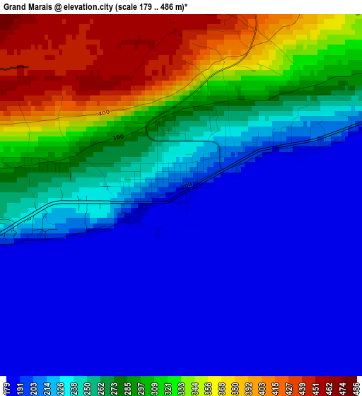
Below is the Elevation map of Grand Marais, which displays elevation range with different colors. Scale of the first map is from 179 to 486 m (587 to 1594 ft) with average elevation of 254.1 meters (=834 ft) [note 1]
These maps also provides idea of topography and contour of this city, they are displayed at different zoom levels. More info about maps, scale and edge coordinates you can find below images.
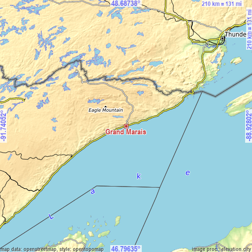
| \ | Map #1 | Topo.Map |
| Scale [m] | 179..486 m | × |
| Scale [ft] | 587..1594 ft | × |
| Average | 254.1 m = 834 ft | × |
| Width | 6.57 km = 4.1 mi | 210.3 km = 130.7 mi |
| Height | 6.57 km = 4.1 mi | 210.2 km = 130.6 mi |
| ↑Max Latitude | 47.779989° | 48.68738° |
| Latitude at center | 47.75045° | 47.75045° |
| ↓Min Latitude | 47.720894° | 46.79635° |
| ← Min Longitude | -90.378215° | -91.74052° |
| Longitude center | -90.33427° | -90.33427° |
| →Max Longitude | -90.290325° | -88.92802° |
Nearby cities:
Cities around Grand Marais sort by population:
• Ashland elevation 195 m
135.3 km,  197°
197°
• Ironwood 459 m
144.6 km,  175°
175°
• Two Harbors 207 m
129.1 km,  231°
231°
• Ely 436 m
115.7 km,  278°
278°
• Washburn 208 m
127 km, 199°
• Hoyt Lakes 447 m
137.6 km,  259°
259°
• Silver Bay 232 m
85.9 km, 233°
• Bessemer 440 m
142.7 km,  171°
171°
• Wakefield 467 m
144.9 km, 168°
• Aurora 451 m
144.6 km, 260°
• Babbitt 451 m
120.5 km,  267°
267°
• Ontonagon 186 m
124.4 km,  141°
141°
Multilingual:
 En español:
Grand Marais elevación 188 m.
 En France:
Grand Marais élévation 188 m.
 Auf Deutsch:
Grand Marais höhe über dem Meeresspiegel ist 188 m.

Sources and notes:
- [note 1] Map square and city borders are not equal. Map elevation data is calculated only from area inside that square.
- [src 1] Elevation data from geonames database provided with same terms of usage.
- [src 2] The elevation map of Grand Marais is generated using elevation data from NASA's 3 arcsec (90m) resolution SRTM data.
- [src 3] Base (background) map © OpenStreetMap contributors tiles are generated by Geofabrik and OpenTopoMap.
Copyright & License:
This Grand Marais Elevation Map is licensed under CC BY-SA. You may reuse any part from this page, if you give a proper credit by linking to this URL:
 More info on terms of use page.