South Lyon elevation
South Lyon (Michigan, Oakland County), United States elevation is 282 meters and South Lyon elevation in feet is 925 ft above sea level [src 1]. South Lyon is a populated place (feature code) with elevation that is 3 meters (10 ft) bigger than average city elevation in United States.
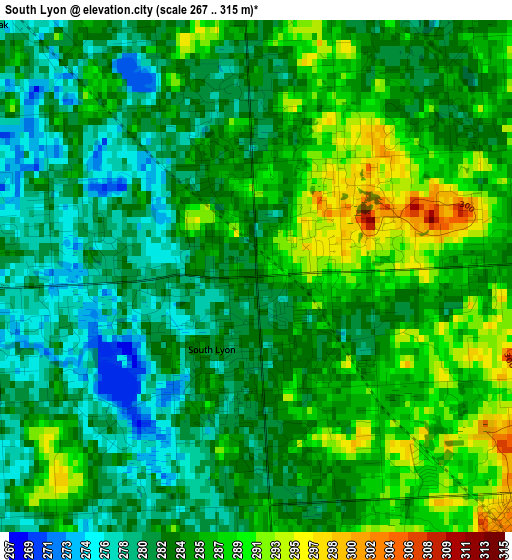
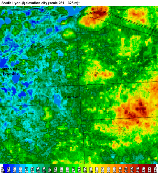
Below is the Elevation map of South Lyon, which displays elevation range with different colors. Scale of the first map is from 267 to 315 m (876 to 1033 ft) with average elevation of 284.1 meters (=932 ft) [note 1]
These maps also provides idea of topography and contour of this city, they are displayed at different zoom levels. More info about maps, scale and edge coordinates you can find below images.
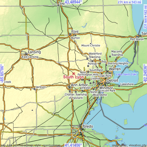
| \ | Map #1 | Map #2 | Topo.Map |
| Scale [m] | 267..315 m | 261..325 m | × |
| Scale [ft] | 876..1033 ft | 856..1066 ft | × |
| Average | 284.1 m = 932 ft | 284.9 m = 935 ft | × |
| Width | 7.21 km = 4.5 mi | 14.42 km = 9 mi | 230.7 km = 143.4 mi |
| Height | 7.21 km = 4.5 mi | 14.42 km = 9 mi | 230.7 km = 143.4 mi |
| ↑Max Latitude | 42.493002° | 42.525397° | 43.48944° |
| Latitude at center | 42.46059° | 42.46059° | 42.46059° |
| ↓Min Latitude | 42.428161° | 42.395716° | 41.41456° |
| ← Min Longitude | -83.695555° | -83.739501° | -85.05786° |
| Longitude center | -83.65161° | -83.65161° | -83.65161° |
| →Max Longitude | -83.607665° | -83.563719° | -82.24536° |
Nearby cities:
Cities around South Lyon sort by population:
• Ann Arbor elevation 271 m
21.6 km,  199°
199°
• Canton 209 m
21.9 km,  140°
140°
• Novi 276 m
14.6 km,  81°
81°
• Wixom 285 m
11.8 km,  52°
52°
• Farmington 228 m
22.6 km,  88°
88°
• Plymouth 222 m
17.9 km,  123°
123°
• Brighton 283 m
13 km,  305°
305°
• Walled Lake 288 m
16.4 km,  58°
58°
• Milford 297 m
15.4 km,  16°
16°
• Whitmore Lake 286 m
8 km,  253°
253°
• Northville 255 m
14.2 km,  103°
103°
• Wolverine Lake 285 m
18.1 km, 53°
Multilingual:
 En español:
South Lyon elevación 282 m.
 En France:
South Lyon élévation 282 m.
 Auf Deutsch:
South Lyon höhe über dem Meeresspiegel ist 282 m.

Sources and notes:
- [note 1] Map square and city borders are not equal. Map elevation data is calculated only from area inside that square.
- [src 1] Elevation data from geonames database provided with same terms of usage.
- [src 2] The elevation map of South Lyon is generated using elevation data from NASA's 3 arcsec (90m) resolution SRTM data.
- [src 3] Base (background) map © OpenStreetMap contributors tiles are generated by Geofabrik and OpenTopoMap.
Copyright & License:
This South Lyon Elevation Map is licensed under CC BY-SA. You may reuse any part from this page, if you give a proper credit by linking to this URL:
 More info on terms of use page.