Lexington elevation
Lexington (Michigan, Sanilac County), United States elevation is 190 meters and Lexington elevation in feet is 623 ft above sea level [src 1]. Lexington is a populated place (feature code) with elevation that is 89 meters (292 ft) smaller than average city elevation in United States.
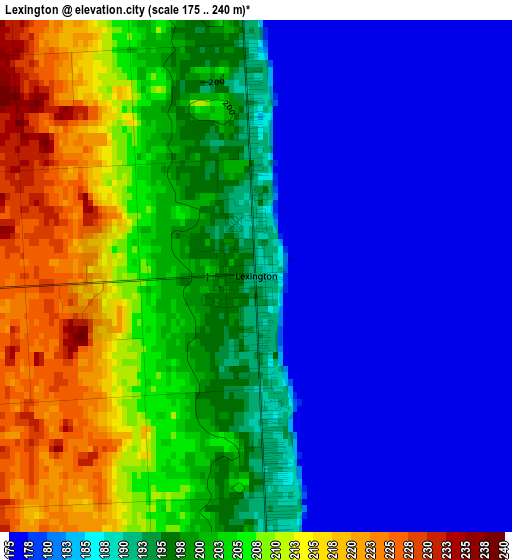
Below is the Elevation map of Lexington, which displays elevation range with different colors. Scale of the first map is from 175 to 240 m (574 to 787 ft) with average elevation of 194.1 meters (=637 ft) [note 1]
These maps also provides idea of topography and contour of this city, they are displayed at different zoom levels. More info about maps, scale and edge coordinates you can find below images.
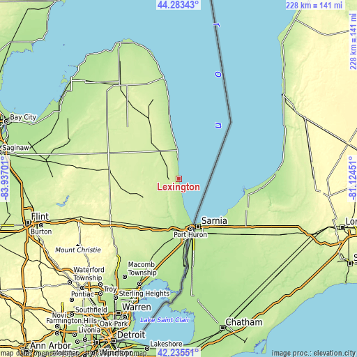
| \ | Map #1 | Topo.Map |
| Scale [m] | 175..240 m | × |
| Scale [ft] | 574..787 ft | × |
| Average | 194.1 m = 637 ft | × |
| Width | 7.12 km = 4.4 mi | 227.7 km = 141.5 mi |
| Height | 7.12 km = 4.4 mi | 227.7 km = 141.5 mi |
| ↑Max Latitude | 43.300071° | 44.28343° |
| Latitude at center | 43.26808° | 43.26808° |
| ↓Min Latitude | 43.236073° | 42.23551° |
| ← Min Longitude | -82.574705° | -83.93701° |
| Longitude center | -82.53076° | -82.53076° |
| →Max Longitude | -82.486815° | -81.12451° |
Nearby cities:
Cities around Lexington sort by population:
• Port Huron elevation 184 m
34.1 km,  165°
165°
• Marysville 191 m
39.7 km, 174°
• Saint Clair 178 m
49.9 km,  175°
175°
• Imlay City 252 m
52 km,  238°
238°
• Sandusky 237 m
29.5 km,  305°
305°
• Croswell 225 m
7.4 km,  276°
276°
• Yale 241 m
26.6 km,  234°
234°
• Capac 247 m
43 km, 228°
• Marlette 255 m
44.9 km, 278°
• Brown City 252 m
37.7 km,  260°
260°
• Memphis 231 m
45.6 km,  205°
205°
• North Branch 248 m
54.1 km,  265°
265°
Multilingual:
 En español:
Lexington elevación 190 m.
 En France:
Lexington élévation 190 m.
 Auf Deutsch:
Lexington höhe über dem Meeresspiegel ist 190 m.

Sources and notes:
- [note 1] Map square and city borders are not equal. Map elevation data is calculated only from area inside that square.
- [src 1] Elevation data from geonames database provided with same terms of usage.
- [src 2] The elevation map of Lexington is generated using elevation data from NASA's 3 arcsec (90m) resolution SRTM data.
- [src 3] Base (background) map © OpenStreetMap contributors tiles are generated by Geofabrik and OpenTopoMap.
Copyright & License:
This Lexington Elevation Map is licensed under CC BY-SA. You may reuse any part from this page, if you give a proper credit by linking to this URL:
 More info on terms of use page.