Marysville elevation
Marysville (Michigan, Saint Clair County), United States elevation is 191 meters and Marysville elevation in feet is 627 ft above sea level [src 1]. Marysville is a populated place (feature code) with elevation that is 88 meters (289 ft) smaller than average city elevation in United States.
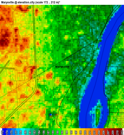
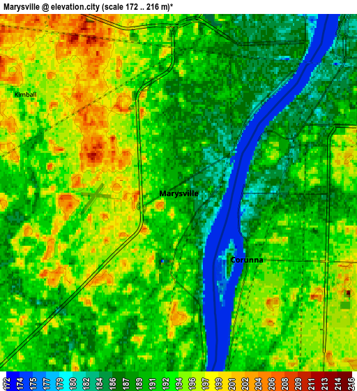
Below is the Elevation map of Marysville, which displays elevation range with different colors. Scale of the first map is from 172 to 212 m (564 to 696 ft) with average elevation of 189.6 meters (=622 ft) [note 1]
These maps also provides idea of topography and contour of this city, they are displayed at different zoom levels. More info about maps, scale and edge coordinates you can find below images.
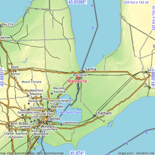
| \ | Map #1 | Map #2 | Topo.Map |
| Scale [m] | 172..212 m | 172..216 m | × |
| Scale [ft] | 564..696 ft | 564..709 ft | × |
| Average | 189.6 m = 622 ft | 191.4 m = 628 ft | × |
| Width | 7.16 km = 4.4 mi | 14.31 km = 8.9 mi | 229 km = 142.3 mi |
| Height | 7.16 km = 4.4 mi | 14.31 km = 8.9 mi | 229 km = 142.3 mi |
| ↑Max Latitude | 42.944707° | 42.976867° | 43.93385° |
| Latitude at center | 42.91253° | 42.91253° | 42.91253° |
| ↓Min Latitude | 42.880336° | 42.848126° | 41.874° |
| ← Min Longitude | -82.530805° | -82.574751° | -83.89311° |
| Longitude center | -82.48686° | -82.48686° | -82.48686° |
| →Max Longitude | -82.442915° | -82.398969° | -81.08061° |
Nearby cities:
Cities around Marysville sort by population:
• Port Huron elevation 184 m
8.2 km,  37°
37°
• New Baltimore 180 m
32.8 km,  218°
218°
• Richmond 223 m
24.7 km,  242°
242°
• Saint Clair 178 m
10.2 km,  179°
179°
• New Haven 192 m
32.7 km,  231°
231°
• Marine City 179 m
21.5 km, 181°
• Algonac 178 m
32.9 km,  186°
186°
• Pearl Beach 176 m
33 km,  195°
195°
• Yale 241 m
35 km,  313°
313°
• Capac 247 m
37.6 km,  287°
287°
• Armada 230 m
33.3 km,  256°
256°
• Memphis 231 m
23 km,  265°
265°
Multilingual:
 En español:
Marysville elevación 191 m.
 En France:
Marysville élévation 191 m.
 Auf Deutsch:
Marysville höhe über dem Meeresspiegel ist 191 m.

Sources and notes:
- [note 1] Map square and city borders are not equal. Map elevation data is calculated only from area inside that square.
- [src 1] Elevation data from geonames database provided with same terms of usage.
- [src 2] The elevation map of Marysville is generated using elevation data from NASA's 3 arcsec (90m) resolution SRTM data.
- [src 3] Base (background) map © OpenStreetMap contributors tiles are generated by Geofabrik and OpenTopoMap.
Copyright & License:
This Marysville Elevation Map is licensed under CC BY-SA. You may reuse any part from this page, if you give a proper credit by linking to this URL:
 More info on terms of use page.