Hubbard Lake elevation
Hubbard Lake (Michigan, Alcona County), United States elevation is 232 meters and Hubbard Lake elevation in feet is 761 ft above sea level [src 1]. Hubbard Lake is a populated place (feature code) with elevation that is 47 meters (154 ft) smaller than average city elevation in United States.
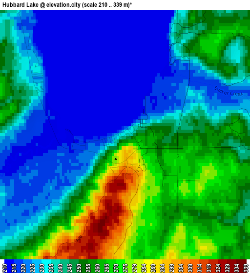
Below is the Elevation map of Hubbard Lake, which displays elevation range with different colors. Scale of the first map is from 210 to 339 m (689 to 1112 ft) with average elevation of 243 meters (=797 ft) [note 1]
These maps also provides idea of topography and contour of this city, they are displayed at different zoom levels. More info about maps, scale and edge coordinates you can find below images.
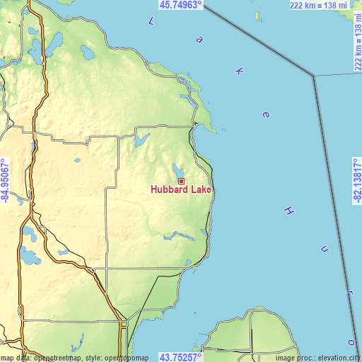
| \ | Map #1 | Topo.Map |
| Scale [m] | 210..339 m | × |
| Scale [ft] | 689..1112 ft | × |
| Average | 243 m = 797 ft | × |
| Width | 6.94 km = 4.3 mi | 222.1 km = 138 mi |
| Height | 6.94 km = 4.3 mi | 222 km = 137.9 mi |
| ↑Max Latitude | 44.790926° | 45.74963° |
| Latitude at center | 44.75973° | 44.75973° |
| ↓Min Latitude | 44.728518° | 43.75257° |
| ← Min Longitude | -83.588365° | -84.95067° |
| Longitude center | -83.54442° | -83.54442° |
| →Max Longitude | -83.500475° | -82.13817° |
Nearby cities:
Cities around Hubbard Lake sort by population:
• Alpena elevation 178 m
34.7 km,  14°
14°
• Skidway Lake 247 m
75 km,  211°
211°
• East Tawas 181 m
53.6 km,  175°
175°
• Rogers City 182 m
76.6 km,  343°
343°
• West Branch 290 m
76.9 km,  225°
225°
• Mio 307 m
47.8 km,  255°
255°
• Tawas City 179 m
54.6 km, 177°
• Sand Lake 243 m
50.2 km,  192°
192°
• Au Sable 181 m
42.3 km,  156°
156°
• Lewiston 379 m
61.6 km,  282°
282°
• Atlanta 268 m
54.5 km,  299°
299°
• Harrisville 193 m
22.8 km,  120°
120°
Multilingual:
 En español:
Hubbard Lake elevación 232 m.
 En France:
Hubbard Lake élévation 232 m.
 Auf Deutsch:
Hubbard Lake höhe über dem Meeresspiegel ist 232 m.

Sources and notes:
- [note 1] Map square and city borders are not equal. Map elevation data is calculated only from area inside that square.
- [src 1] Elevation data from geonames database provided with same terms of usage.
- [src 2] The elevation map of Hubbard Lake is generated using elevation data from NASA's 3 arcsec (90m) resolution SRTM data.
- [src 3] Base (background) map © OpenStreetMap contributors tiles are generated by Geofabrik and OpenTopoMap.
Copyright & License:
This Hubbard Lake Elevation Map is licensed under CC BY-SA. You may reuse any part from this page, if you give a proper credit by linking to this URL:
 More info on terms of use page.