Sand Lake elevation
Sand Lake (Michigan, Iosco County), United States elevation is 243 meters and Sand Lake elevation in feet is 797 ft above sea level [src 1]. Sand Lake is a populated place (feature code) with elevation that is 36 meters (118 ft) smaller than average city elevation in United States.
Below is the Elevation map of Sand Lake, which displays elevation range with different colors. Scale of the first map is from 216 to 261 m (709 to 856 ft) with average elevation of 240.5 meters (=789 ft) [note 1]
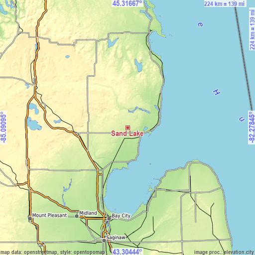
These maps also provides idea of topography and contour of this city, they are displayed at different zoom levels. More info about maps, scale and edge coordinates you can find below images.
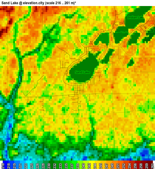
| \ | Map #1 | Topo.Map |
| Scale [m] | 216..261 m | × |
| Scale [ft] | 709..856 ft | × |
| Average | 240.5 m = 789 ft | × |
| Width | 6.99 km = 4.3 mi | 223.7 km = 139 mi |
| Height | 6.99 km = 4.3 mi | 223.7 km = 139 mi |
| ↑Max Latitude | 44.350613° | 45.31667° |
| Latitude at center | 44.31918° | 44.31918° |
| ↓Min Latitude | 44.287731° | 43.30444° |
| ← Min Longitude | -83.728645° | -85.09095° |
| Longitude center | -83.6847° | -83.6847° |
| →Max Longitude | -83.640755° | -82.27845° |
Nearby cities:
Cities around Sand Lake sort by population:
• Skidway Lake elevation 247 m
31.7 km,  241°
241°
• East Tawas 181 m
16.1 km,  105°
105°
• Saint Helen 363 m
57.9 km,  274°
274°
• West Branch 290 m
44.3 km,  263°
263°
• Mio 307 m
51.2 km,  316°
316°
• Tawas City 179 m
14.6 km, 112°
• Standish 188 m
43.3 km,  210°
210°
• Au Sable 181 m
29.8 km,  70°
70°
• Pinconning 181 m
56.4 km,  203°
203°
• Pigeon 191 m
63.7 km,  148°
148°
• Hubbard Lake 232 m
50.2 km,  12°
12°
• Harrisville 193 m
48.6 km,  39°
39°
Multilingual:
 En español:
Sand Lake elevación 243 m.
 En France:
Sand Lake élévation 243 m.
 Auf Deutsch:
Sand Lake höhe über dem Meeresspiegel ist 243 m.

Sources and notes:
- [note 1] Map square and city borders are not equal. Map elevation data is calculated only from area inside that square.
- [src 1] Elevation data from geonames database provided with same terms of usage.
- [src 2] The elevation map of Sand Lake is generated using elevation data from NASA's 3 arcsec (90m) resolution SRTM data.
- [src 3] Base (background) map © OpenStreetMap contributors tiles are generated by Geofabrik and OpenTopoMap.
Copyright & License:
This Sand Lake Elevation Map is licensed under CC BY-SA. You may reuse any part from this page, if you give a proper credit by linking to this URL:
 More info on terms of use page.