Rogers City elevation
Rogers City (Michigan, Presque Isle County), United States elevation is 182 meters and Rogers City elevation in feet is 597 ft above sea level [src 1]. Rogers City is a seat of a second-order administrative division (feature code) with elevation that is 97 meters (318 ft) smaller than average city elevation in United States.
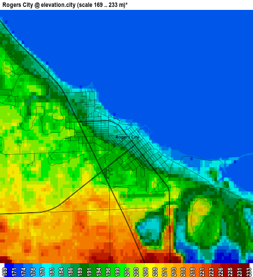
Below is the Elevation map of Rogers City, which displays elevation range with different colors. Scale of the first map is from 169 to 233 m (554 to 764 ft) with average elevation of 189 meters (=620 ft) [note 1]
These maps also provides idea of topography and contour of this city, they are displayed at different zoom levels. More info about maps, scale and edge coordinates you can find below images.
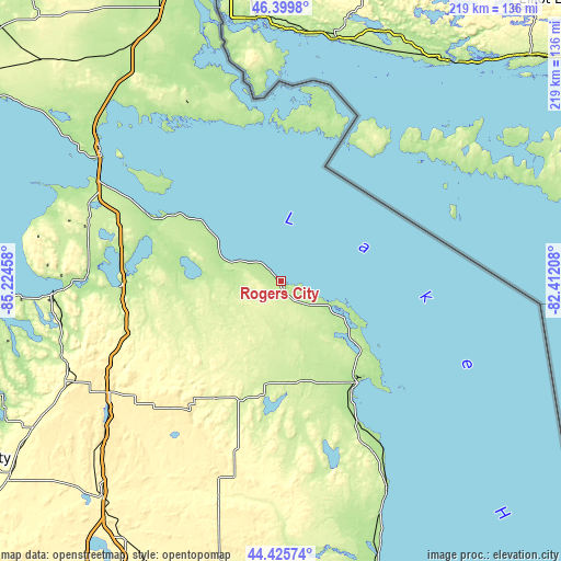
| \ | Map #1 | Topo.Map |
| Scale [m] | 169..233 m | × |
| Scale [ft] | 554..764 ft | × |
| Average | 189 m = 620 ft | × |
| Width | 6.86 km = 4.3 mi | 219.5 km = 136.4 mi |
| Height | 6.86 km = 4.3 mi | 219.5 km = 136.4 mi |
| ↑Max Latitude | 45.452236° | 46.3998° |
| Latitude at center | 45.4214° | 45.4214° |
| ↓Min Latitude | 45.390547° | 44.42574° |
| ← Min Longitude | -83.862275° | -85.22458° |
| Longitude center | -83.81833° | -83.81833° |
| →Max Longitude | -83.774385° | -82.41208° |
Nearby cities:
Cities around Rogers City sort by population:
• Alpena elevation 178 m
50.1 km,  142°
142°
• Petoskey 204 m
88.9 km,  266°
266°
• Cheboygan 177 m
56.9 km,  296°
296°
• Gaylord 410 m
80.1 km,  236°
236°
• Saint Ignace 189 m
86.3 km, 304°
• Indian River 185 m
62 km, 269°
• Mio 307 m
89 km,  195°
195°
• Lewiston 379 m
70.9 km,  212°
212°
• Harbor Springs 199 m
91.6 km, 270°
• Hubbard Lake 232 m
76.6 km,  163°
163°
• Atlanta 268 m
52.9 km, 208°
• Harrisville 193 m
94.5 km,  154°
154°
Multilingual:
 En español:
Rogers City elevación 182 m.
 En France:
Rogers City élévation 182 m.
 Auf Deutsch:
Rogers City höhe über dem Meeresspiegel ist 182 m.

Sources and notes:
- [note 1] Map square and city borders are not equal. Map elevation data is calculated only from area inside that square.
- [src 1] Elevation data from geonames database provided with same terms of usage.
- [src 2] The elevation map of Rogers City is generated using elevation data from NASA's 3 arcsec (90m) resolution SRTM data.
- [src 3] Base (background) map © OpenStreetMap contributors tiles are generated by Geofabrik and OpenTopoMap.
Copyright & License:
This Rogers City Elevation Map is licensed under CC BY-SA. You may reuse any part from this page, if you give a proper credit by linking to this URL:
 More info on terms of use page.