Evart elevation
Evart (Michigan, Osceola County), United States elevation is 310 meters and Evart elevation in feet is 1017 ft above sea level [src 1]. Evart is a populated place (feature code) with elevation that is 31 meters (102 ft) bigger than average city elevation in United States.
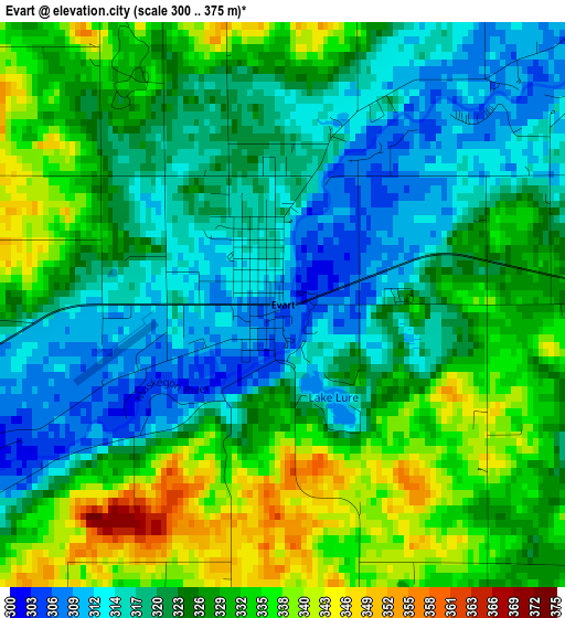
Below is the Elevation map of Evart, which displays elevation range with different colors. Scale of the first map is from 300 to 375 m (984 to 1230 ft) with average elevation of 325 meters (=1066 ft) [note 1]
These maps also provides idea of topography and contour of this city, they are displayed at different zoom levels. More info about maps, scale and edge coordinates you can find below images.
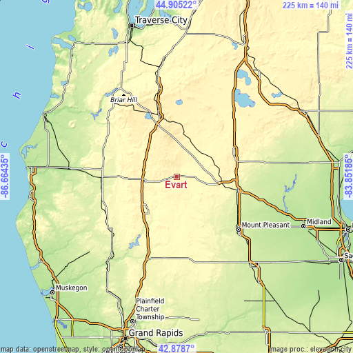
| \ | Map #1 | Topo.Map |
| Scale [m] | 300..375 m | × |
| Scale [ft] | 984..1230 ft | × |
| Average | 325 m = 1066 ft | × |
| Width | 7.04 km = 4.4 mi | 225.3 km = 140 mi |
| Height | 7.04 km = 4.4 mi | 225.3 km = 140 mi |
| ↑Max Latitude | 43.932236° | 44.90522° |
| Latitude at center | 43.90058° | 43.90058° |
| ↓Min Latitude | 43.868907° | 42.8787° |
| ← Min Longitude | -85.302045° | -86.66435° |
| Longitude center | -85.2581° | -85.2581° |
| →Max Longitude | -85.214155° | -83.85185° |
Nearby cities:
Cities around Evart sort by population:
• Mount Pleasant elevation 236 m
51.8 km,  130°
130°
• Big Rapids 285 m
28.9 km,  218°
218°
• Cadillac 402 m
40.7 km,  343°
343°
• Clare 255 m
40.3 km,  102°
102°
• Canadian Lakes 303 m
35.9 km,  185°
185°
• Reed City 317 m
20.4 km,  261°
261°
• Harrison 354 m
39 km,  70°
70°
• Lake Isabella 271 m
35.4 km,  143°
143°
• Coleman 232 m
56.2 km,  106°
106°
• Baldwin 258 m
47.6 km,  270°
270°
• Lakeview 292 m
50.5 km,  181°
181°
• Lake City 382 m
48.5 km,  4°
4°
Multilingual:
 En español:
Evart elevación 310 m.
 En France:
Evart élévation 310 m.


Sources and notes:
- [note 1] Map square and city borders are not equal. Map elevation data is calculated only from area inside that square.
- [src 1] Elevation data from geonames database provided with same terms of usage.
- [src 2] The elevation map of Evart is generated using elevation data from NASA's 3 arcsec (90m) resolution SRTM data.
- [src 3] Base (background) map © OpenStreetMap contributors tiles are generated by Geofabrik and OpenTopoMap.
Copyright & License:
This Evart Elevation Map is licensed under CC BY-SA. You may reuse any part from this page, if you give a proper credit by linking to this URL:
 More info on terms of use page.