Harrison elevation
Harrison (Michigan, Clare County), United States elevation is 354 meters and Harrison elevation in feet is 1161 ft above sea level [src 1]. Harrison is a seat of a second-order administrative division (feature code) with elevation that is 75 meters (246 ft) bigger than average city elevation in United States.
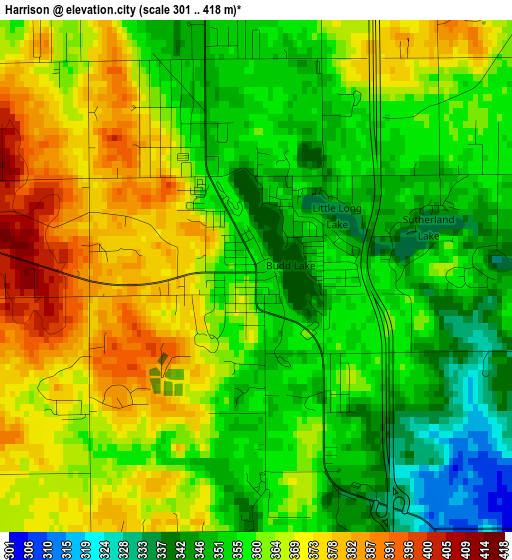
Below is the Elevation map of Harrison, which displays elevation range with different colors. Scale of the first map is from 301 to 418 m (988 to 1371 ft) with average elevation of 360.4 meters (=1182 ft) [note 1]
These maps also provides idea of topography and contour of this city, they are displayed at different zoom levels. More info about maps, scale and edge coordinates you can find below images.
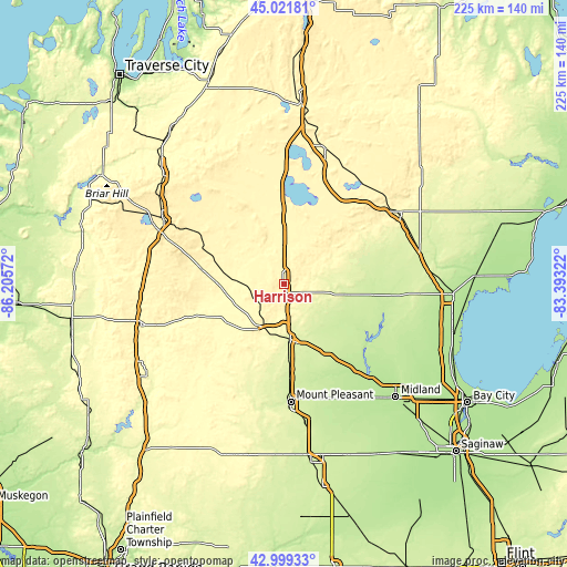
| \ | Map #1 | Topo.Map |
| Scale [m] | 301..418 m | × |
| Scale [ft] | 988..1371 ft | × |
| Average | 360.4 m = 1182 ft | × |
| Width | 7.03 km = 4.4 mi | 224.9 km = 139.7 mi |
| Height | 7.03 km = 4.4 mi | 224.9 km = 139.7 mi |
| ↑Max Latitude | 44.050783° | 45.02181° |
| Latitude at center | 44.01919° | 44.01919° |
| ↓Min Latitude | 43.98758° | 42.99933° |
| ← Min Longitude | -84.843415° | -86.20572° |
| Longitude center | -84.79947° | -84.79947° |
| →Max Longitude | -84.755525° | -83.39322° |
Nearby cities:
Cities around Harrison sort by population:
• Mount Pleasant elevation 236 m
46.9 km,  176°
176°
• Houghton Lake 347 m
33 km,  4°
4°
• Clare 255 m
22.3 km,  173°
173°
• Gladwin 240 m
25.4 km,  99°
99°
• Saint Helen 363 m
49.3 km,  39°
39°
• West Branch 290 m
53.1 km,  57°
57°
• Evart 310 m
39 km,  250°
250°
• Prudenville 347 m
33.2 km,  20°
20°
• Lake Isabella 271 m
44.7 km,  200°
200°
• Coleman 232 m
33.8 km,  149°
149°
• Beaverton 222 m
29.4 km,  121°
121°
• Lake City 382 m
48.3 km,  316°
316°
Multilingual:
 En español:
Harrison elevación 354 m.
 En France:
Harrison élévation 354 m.
 Auf Deutsch:
Harrison höhe über dem Meeresspiegel ist 354 m.

Sources and notes:
- [note 1] Map square and city borders are not equal. Map elevation data is calculated only from area inside that square.
- [src 1] Elevation data from geonames database provided with same terms of usage.
- [src 2] The elevation map of Harrison is generated using elevation data from NASA's 3 arcsec (90m) resolution SRTM data.
- [src 3] Base (background) map © OpenStreetMap contributors tiles are generated by Geofabrik and OpenTopoMap.
Copyright & License:
This Harrison Elevation Map is licensed under CC BY-SA. You may reuse any part from this page, if you give a proper credit by linking to this URL:
 More info on terms of use page.