Big Rapids elevation
Big Rapids (Michigan, Mecosta County), United States elevation is 285 meters and Big Rapids elevation in feet is 935 ft above sea level [src 1]. Big Rapids is a seat of a second-order administrative division (feature code) with elevation that is 6 meters (20 ft) bigger than average city elevation in United States.
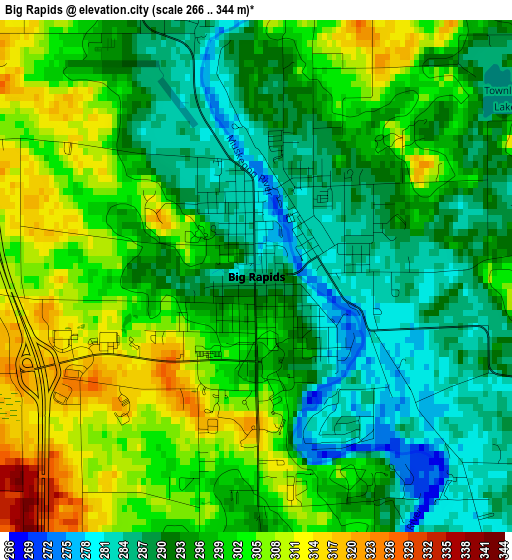
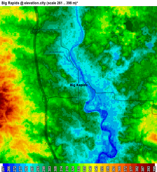
Below is the Elevation map of Big Rapids, which displays elevation range with different colors. Scale of the first map is from 266 to 344 m (873 to 1129 ft) with average elevation of 296.7 meters (=973 ft) [note 1]
These maps also provides idea of topography and contour of this city, they are displayed at different zoom levels. More info about maps, scale and edge coordinates you can find below images.
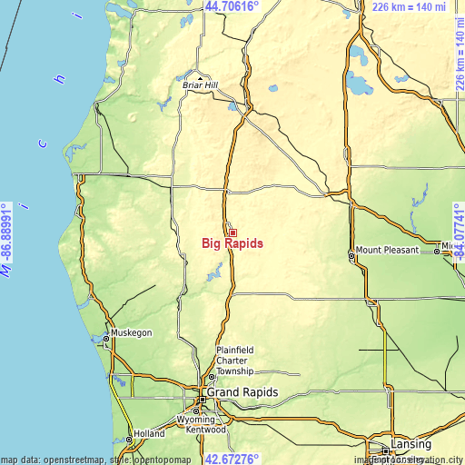
| \ | Map #1 | Map #2 | Topo.Map |
| Scale [m] | 266..344 m | 261..398 m | × |
| Scale [ft] | 873..1129 ft | 856..1306 ft | × |
| Average | 296.7 m = 973 ft | 311.7 m = 1023 ft | × |
| Width | 7.07 km = 4.4 mi | 14.13 km = 8.8 mi | 226.1 km = 140.5 mi |
| Height | 7.07 km = 4.4 mi | 14.13 km = 8.8 mi | 226.1 km = 140.5 mi |
| ↑Max Latitude | 43.729844° | 43.76159° | 44.70616° |
| Latitude at center | 43.69808° | 43.69808° | 43.69808° |
| ↓Min Latitude | 43.6663° | 43.634502° | 42.67276° |
| ← Min Longitude | -85.527605° | -85.571551° | -86.88991° |
| Longitude center | -85.48366° | -85.48366° | -85.48366° |
| →Max Longitude | -85.439715° | -85.395769° | -84.07741° |
Nearby cities:
Cities around Big Rapids sort by population:
• Fremont elevation 252 m
44.9 km,  235°
235°
• Cedar Springs 259 m
53.1 km,  185°
185°
• Canadian Lakes 303 m
19.7 km,  132°
132°
• Reed City 317 m
19.8 km,  353°
353°
• Newaygo 213 m
40.1 km,  219°
219°
• Evart 310 m
28.9 km,  38°
38°
• Howard City 268 m
33.7 km,  177°
177°
• Lake Isabella 271 m
39.6 km,  98°
98°
• White Cloud 265 m
28.4 km,  234°
234°
• Edmore 297 m
48.2 km, 131°
• Baldwin 258 m
37.2 km,  307°
307°
• Lakeview 292 m
32.7 km,  148°
148°
Multilingual:
 En español:
Big Rapids elevación 285 m.
 En France:
Big Rapids élévation 285 m.
 Auf Deutsch:
Big Rapids höhe über dem Meeresspiegel ist 285 m.

Sources and notes:
- [note 1] Map square and city borders are not equal. Map elevation data is calculated only from area inside that square.
- [src 1] Elevation data from geonames database provided with same terms of usage.
- [src 2] The elevation map of Big Rapids is generated using elevation data from NASA's 3 arcsec (90m) resolution SRTM data.
- [src 3] Base (background) map © OpenStreetMap contributors tiles are generated by Geofabrik and OpenTopoMap.
Copyright & License:
This Big Rapids Elevation Map is licensed under CC BY-SA. You may reuse any part from this page, if you give a proper credit by linking to this URL:
 More info on terms of use page.