Breckenridge elevation
Breckenridge (Michigan, Gratiot County), United States elevation is 226 meters and Breckenridge elevation in feet is 741 ft above sea level [src 1]. Breckenridge is a populated place (feature code) with elevation that is 53 meters (174 ft) smaller than average city elevation in United States.
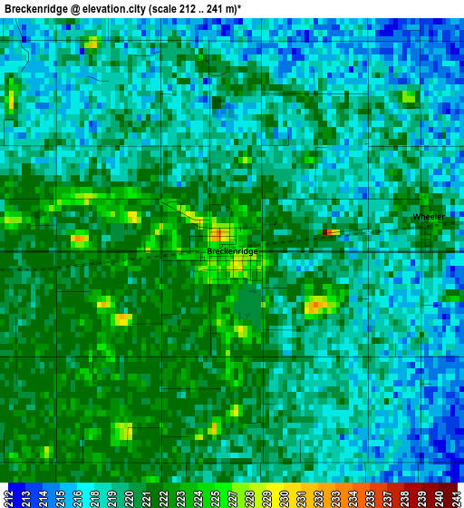
Below is the Elevation map of Breckenridge, which displays elevation range with different colors. Scale of the first map is from 212 to 241 m (696 to 791 ft) with average elevation of 219.5 meters (=720 ft) [note 1]
These maps also provides idea of topography and contour of this city, they are displayed at different zoom levels. More info about maps, scale and edge coordinates you can find below images.
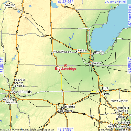
| \ | Map #1 | Topo.Map |
| Scale [m] | 212..241 m | × |
| Scale [ft] | 696..791 ft | × |
| Average | 219.5 m = 720 ft | × |
| Width | 7.1 km = 4.4 mi | 227.2 km = 141.2 mi |
| Height | 7.1 km = 4.4 mi | 227.2 km = 141.2 mi |
| ↑Max Latitude | 43.439997° | 44.42107° |
| Latitude at center | 43.40808° | 43.40808° |
| ↓Min Latitude | 43.376146° | 42.37786° |
| ← Min Longitude | -84.518945° | -85.88125° |
| Longitude center | -84.475° | -84.475° |
| →Max Longitude | -84.431055° | -83.06875° |
Nearby cities:
Cities around Breckenridge sort by population:
• Midland elevation 193 m
29.5 km,  38°
38°
• Mount Pleasant 236 m
31.6 km,  311°
311°
• Saginaw Township North 191 m
38.2 km,  81°
81°
• Alma 227 m
15.3 km,  257°
257°
• Saint Louis 224 m
10.6 km,  270°
270°
• Freeland 190 m
31.3 km,  65°
65°
• Shields 184 m
33.8 km,  88°
88°
• Ithaca 241 m
16.8 km,  219°
219°
• Chesaning 193 m
38.3 km,  130°
130°
• Saint Charles 182 m
29.7 km,  114°
114°
• Shepherd 238 m
22 km, 306°
• Hemlock 200 m
19.8 km, 87°
Multilingual:
 En español:
Breckenridge elevación 226 m.
 En France:
Breckenridge élévation 226 m.
 Auf Deutsch:
Breckenridge höhe über dem Meeresspiegel ist 226 m.

Sources and notes:
- [note 1] Map square and city borders are not equal. Map elevation data is calculated only from area inside that square.
- [src 1] Elevation data from geonames database provided with same terms of usage.
- [src 2] The elevation map of Breckenridge is generated using elevation data from NASA's 3 arcsec (90m) resolution SRTM data.
- [src 3] Base (background) map © OpenStreetMap contributors tiles are generated by Geofabrik and OpenTopoMap.
Copyright & License:
This Breckenridge Elevation Map is licensed under CC BY-SA. You may reuse any part from this page, if you give a proper credit by linking to this URL:
 More info on terms of use page.