Chesaning elevation
Chesaning (Michigan, Saginaw County), United States elevation is 193 meters and Chesaning elevation in feet is 633 ft above sea level [src 1]. Chesaning is a populated place (feature code) with elevation that is 86 meters (282 ft) smaller than average city elevation in United States.
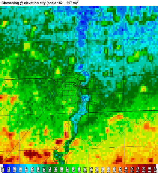
Below is the Elevation map of Chesaning, which displays elevation range with different colors. Scale of the first map is from 182 to 217 m (597 to 712 ft) with average elevation of 195.6 meters (=642 ft) [note 1]
These maps also provides idea of topography and contour of this city, they are displayed at different zoom levels. More info about maps, scale and edge coordinates you can find below images.
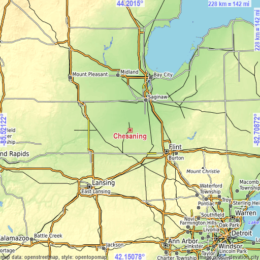
| \ | Map #1 | Topo.Map |
| Scale [m] | 182..217 m | × |
| Scale [ft] | 597..712 ft | × |
| Average | 195.6 m = 642 ft | × |
| Width | 7.13 km = 4.4 mi | 228 km = 141.7 mi |
| Height | 7.13 km = 4.4 mi | 228 km = 141.7 mi |
| ↑Max Latitude | 43.216784° | 44.2015° |
| Latitude at center | 43.18475° | 43.18475° |
| ↓Min Latitude | 43.152699° | 42.15078° |
| ← Min Longitude | -84.158915° | -85.52122° |
| Longitude center | -84.11497° | -84.11497° |
| →Max Longitude | -84.071025° | -82.70872° |
Nearby cities:
Cities around Chesaning sort by population:
• Owosso elevation 223 m
21.4 km,  193°
193°
• Flushing 215 m
25.3 km,  122°
122°
• Bridgeport 184 m
27.1 km,  44°
44°
• Shields 184 m
26.1 km,  10°
10°
• New Haven 214 m
10.6 km,  197°
197°
• Corunna 230 m
22.5 km,  180°
180°
• Saint Charles 182 m
12.6 km,  350°
350°
• Ovid 224 m
28.8 km,  226°
226°
• Montrose 206 m
18 km,  92°
92°
• Birch Run 197 m
27 km,  74°
74°
• Hemlock 200 m
27.2 km,  339°
339°
• Burt 198 m
17.9 km, 71°
Multilingual:
 En español:
Chesaning elevación 193 m.
 En France:
Chesaning élévation 193 m.
 Auf Deutsch:
Chesaning höhe über dem Meeresspiegel ist 193 m.

Sources and notes:
- [note 1] Map square and city borders are not equal. Map elevation data is calculated only from area inside that square.
- [src 1] Elevation data from geonames database provided with same terms of usage.
- [src 2] The elevation map of Chesaning is generated using elevation data from NASA's 3 arcsec (90m) resolution SRTM data.
- [src 3] Base (background) map © OpenStreetMap contributors tiles are generated by Geofabrik and OpenTopoMap.
Copyright & License:
This Chesaning Elevation Map is licensed under CC BY-SA. You may reuse any part from this page, if you give a proper credit by linking to this URL:
 More info on terms of use page.