Alma elevation
Alma (Michigan, Gratiot County), United States elevation is 227 meters and Alma elevation in feet is 745 ft above sea level [src 1]. Alma is a populated place (feature code) with elevation that is 52 meters (171 ft) smaller than average city elevation in United States.
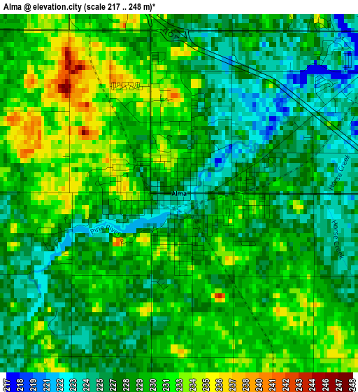
Below is the Elevation map of Alma, which displays elevation range with different colors. Scale of the first map is from 217 to 248 m (712 to 814 ft) with average elevation of 228.8 meters (=751 ft) [note 1]
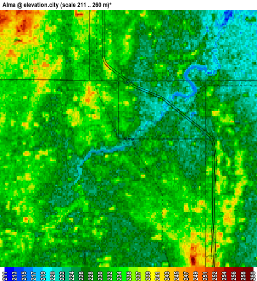
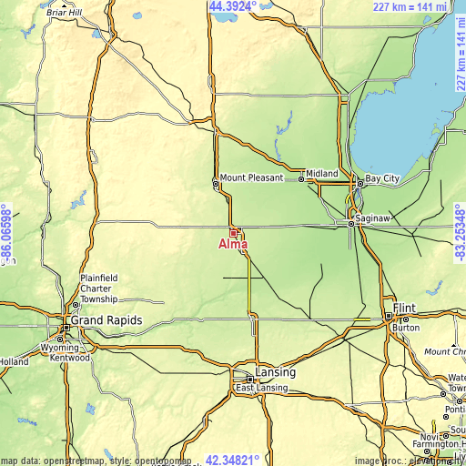
These maps also provides idea of topography and contour of this city, they are displayed at different zoom levels. More info about maps, scale and edge coordinates you can find below images.
| \ | Map #1 | Map #2 | Topo.Map |
| Scale [m] | 217..248 m | 211..260 m | × |
| Scale [ft] | 712..814 ft | 692..853 ft | × |
| Average | 228.8 m = 751 ft | 230.2 m = 755 ft | × |
| Width | 7.1 km = 4.4 mi | 14.21 km = 8.8 mi | 227.3 km = 141.2 mi |
| Height | 7.1 km = 4.4 mi | 14.21 km = 8.8 mi | 227.3 km = 141.2 mi |
| ↑Max Latitude | 43.410852° | 43.442768° | 44.3924° |
| Latitude at center | 43.37892° | 43.37892° | 43.37892° |
| ↓Min Latitude | 43.346971° | 43.315005° | 42.34821° |
| ← Min Longitude | -84.703675° | -84.747621° | -86.06598° |
| Longitude center | -84.65973° | -84.65973° | -84.65973° |
| →Max Longitude | -84.615785° | -84.571839° | -83.25348° |
Nearby cities:
Cities around Alma sort by population:
• Midland elevation 193 m
42.4 km,  51°
51°
• Mount Pleasant 236 m
25.8 km,  340°
340°
• Saint Louis 224 m
5.4 km, 52°
• Ithaca 241 m
10.6 km,  156°
156°
• Lake Isabella 271 m
40.1 km,  317°
317°
• Shepherd 238 m
16.4 km,  350°
350°
• Hemlock 200 m
34.9 km,  83°
83°
• Stanton 283 m
35.4 km,  254°
254°
• Breckenridge 226 m
15.3 km, 77°
• Coleman 232 m
42.4 km,  8°
8°
• Edmore 297 m
30.8 km,  276°
276°
• Carson City 234 m
27.1 km,  213°
213°
Multilingual:
 En español:
Alma elevación 227 m.
 En France:
Alma élévation 227 m.


Sources and notes:
- [note 1] Map square and city borders are not equal. Map elevation data is calculated only from area inside that square.
- [src 1] Elevation data from geonames database provided with same terms of usage.
- [src 2] The elevation map of Alma is generated using elevation data from NASA's 3 arcsec (90m) resolution SRTM data.
- [src 3] Base (background) map © OpenStreetMap contributors tiles are generated by Geofabrik and OpenTopoMap.
Copyright & License:
This Alma Elevation Map is licensed under CC BY-SA. You may reuse any part from this page, if you give a proper credit by linking to this URL:
 More info on terms of use page.