Shapleigh elevation
Shapleigh (Maine, York County), United States elevation is 178 meters and Shapleigh elevation in feet is 584 ft above sea level [src 1]. Shapleigh is a populated place (feature code) with elevation that is 101 meters (331 ft) smaller than average city elevation in United States.
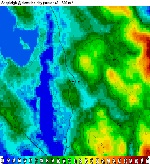
Below is the Elevation map of Shapleigh, which displays elevation range with different colors. Scale of the first map is from 142 to 300 m (466 to 984 ft) with average elevation of 189.3 meters (=621 ft) [note 1]
These maps also provides idea of topography and contour of this city, they are displayed at different zoom levels. More info about maps, scale and edge coordinates you can find below images.
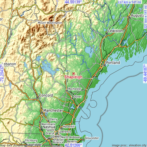
| \ | Map #1 | Topo.Map |
| Scale [m] | 142..300 m | × |
| Scale [ft] | 466..984 ft | × |
| Average | 189.3 m = 621 ft | × |
| Width | 7.08 km = 4.4 mi | 226.7 km = 140.9 mi |
| Height | 7.08 km = 4.4 mi | 226.7 km = 140.9 mi |
| ↑Max Latitude | 43.572487° | 44.55139° |
| Latitude at center | 43.54064° | 43.54064° |
| ↓Min Latitude | 43.508776° | 42.51266° |
| ← Min Longitude | -70.892065° | -72.25437° |
| Longitude center | -70.84812° | -70.84812° |
| →Max Longitude | -70.804175° | -69.44187° |
Nearby cities:
Cities around Shapleigh sort by population:
• Sanford elevation 96 m
12.8 km,  152°
152°
• Waterboro 82 m
10.7 km,  92°
92°
• Lebanon 90 m
16.2 km,  180°
180°
• Wakefield 210 m
15 km,  281°
281°
• South Sanford 86 m
16.7 km, 149°
• Springvale 110 m
9.3 km, 151°
• Lake Arrowhead 112 m
16.4 km,  33°
33°
• Alfred 83 m
12.7 km,  124°
124°
• Limerick 166 m
17 km,  14°
14°
• Acton 221 m
5 km,  261°
261°
• Newfield 123 m
12 km,  0°
0°
• Sanbornville 176 m
14.8 km, 275°
Multilingual:
 En español:
Shapleigh elevación 178 m.
 En France:
Shapleigh élévation 178 m.
 Auf Deutsch:
Shapleigh höhe über dem Meeresspiegel ist 178 m.

Sources and notes:
- [note 1] Map square and city borders are not equal. Map elevation data is calculated only from area inside that square.
- [src 1] Elevation data from geonames database provided with same terms of usage.
- [src 2] The elevation map of Shapleigh is generated using elevation data from NASA's 3 arcsec (90m) resolution SRTM data.
- [src 3] Base (background) map © OpenStreetMap contributors tiles are generated by Geofabrik and OpenTopoMap.
Copyright & License:
This Shapleigh Elevation Map is licensed under CC BY-SA. You may reuse any part from this page, if you give a proper credit by linking to this URL:
 More info on terms of use page.