Limerick elevation
Limerick (Maine, York County), United States elevation is 166 meters and Limerick elevation in feet is 545 ft above sea level [src 1]. Limerick is a populated place (feature code) with elevation that is 113 meters (371 ft) smaller than average city elevation in United States.
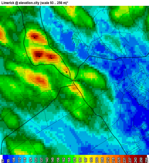
Below is the Elevation map of Limerick, which displays elevation range with different colors. Scale of the first map is from 93 to 256 m (305 to 840 ft) with average elevation of 138.5 meters (=454 ft) [note 1]
These maps also provides idea of topography and contour of this city, they are displayed at different zoom levels. More info about maps, scale and edge coordinates you can find below images.
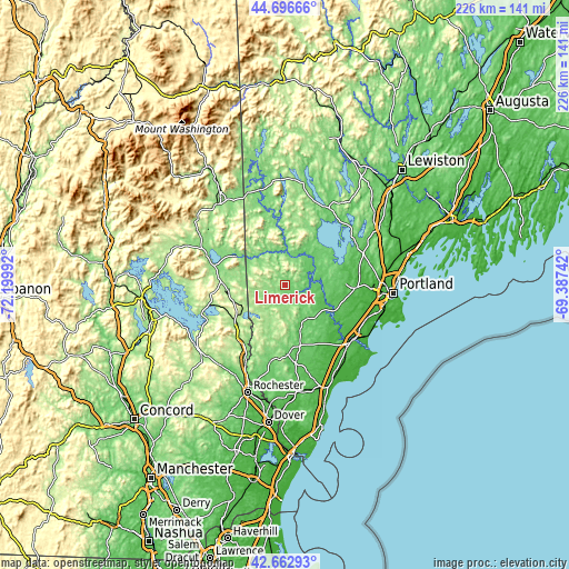
| \ | Map #1 | Topo.Map |
| Scale [m] | 93..256 m | × |
| Scale [ft] | 305..840 ft | × |
| Average | 138.5 m = 454 ft | × |
| Width | 7.07 km = 4.4 mi | 226.1 km = 140.5 mi |
| Height | 7.07 km = 4.4 mi | 226.1 km = 140.5 mi |
| ↑Max Latitude | 43.720179° | 44.69666° |
| Latitude at center | 43.68841° | 43.68841° |
| ↓Min Latitude | 43.656624° | 42.66293° |
| ← Min Longitude | -70.837615° | -72.19992° |
| Longitude center | -70.79367° | -70.79367° |
| →Max Longitude | -70.749725° | -69.38742° |
Nearby cities:
Cities around Limerick sort by population:
• Waterboro elevation 82 m
18.1 km,  159°
159°
• Hollis Center 59 m
18.6 km,  119°
119°
• Limington 145 m
8.2 km,  54°
54°
• Lake Arrowhead 112 m
5.5 km, 120°
• Shapleigh 178 m
17 km,  194°
194°
• Acton 221 m
19.5 km,  208°
208°
• Parsonsfield 220 m
11.7 km,  291°
291°
• Porter 125 m
16.4 km,  316°
316°
• Newfield 123 m
6.2 km,  223°
223°
• Effingham 183 m
18.2 km,  296°
296°
• Cornish 108 m
13 km,  357°
357°
• Steep Falls 93 m
16.3 km,  44°
44°
Multilingual:
 En español:
Limerick elevación 166 m.
 En France:
Limerick élévation 166 m.
 Auf Deutsch:
Limerick höhe über dem Meeresspiegel ist 166 m.

Sources and notes:
- [note 1] Map square and city borders are not equal. Map elevation data is calculated only from area inside that square.
- [src 1] Elevation data from geonames database provided with same terms of usage.
- [src 2] The elevation map of Limerick is generated using elevation data from NASA's 3 arcsec (90m) resolution SRTM data.
- [src 3] Base (background) map © OpenStreetMap contributors tiles are generated by Geofabrik and OpenTopoMap.
Copyright & License:
This Limerick Elevation Map is licensed under CC BY-SA. You may reuse any part from this page, if you give a proper credit by linking to this URL:
 More info on terms of use page.