Alfred elevation
Alfred (Maine, York County), United States elevation is 83 meters and Alfred elevation in feet is 272 ft above sea level [src 1]. Alfred is a seat of a second-order administrative division (feature code) with elevation that is 196 meters (643 ft) smaller than average city elevation in United States.
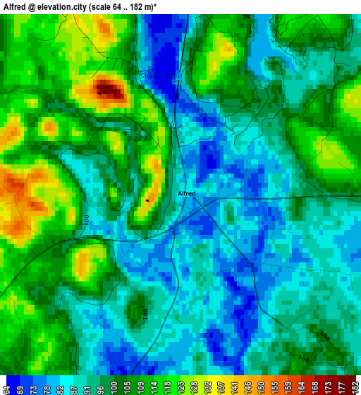
Below is the Elevation map of Alfred, which displays elevation range with different colors. Scale of the first map is from 64 to 182 m (210 to 597 ft) with average elevation of 99.2 meters (=325 ft) [note 1]
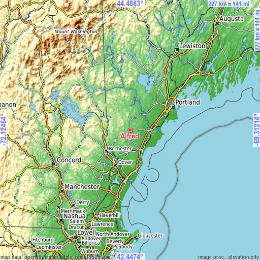
These maps also provides idea of topography and contour of this city, they are displayed at different zoom levels. More info about maps, scale and edge coordinates you can find below images.
| \ | Map #1 | Topo.Map |
| Scale [m] | 64..182 m | × |
| Scale [ft] | 210..597 ft | × |
| Average | 99.2 m = 325 ft | × |
| Width | 7.09 km = 4.4 mi | 226.9 km = 141 mi |
| Height | 7.09 km = 4.4 mi | 226.9 km = 141 mi |
| ↑Max Latitude | 43.508351° | 44.4883° |
| Latitude at center | 43.47647° | 43.47647° |
| ↓Min Latitude | 43.444572° | 42.4474° |
| ← Min Longitude | -70.762335° | -72.12464° |
| Longitude center | -70.71839° | -70.71839° |
| →Max Longitude | -70.674445° | -69.31214° |
Nearby cities:
Cities around Alfred sort by population:
• Sanford elevation 96 m
6.1 km,  227°
227°
• Waterboro 82 m
6.6 km,  2°
2°
• Lebanon 90 m
14.1 km, 229°
• Kennebunk 24 m
17.4 km,  126°
126°
• Hollis Center 59 m
17.5 km,  35°
35°
• South Sanford 86 m
7.5 km,  195°
195°
• Springvale 110 m
6.2 km,  259°
259°
• Shapleigh 178 m
12.7 km,  304°
304°
• Acton 221 m
16.7 km,  292°
292°
• Dayton 78 m
14.1 km,  54°
54°
• North Berwick 43 m
19.2 km,  183°
183°
• West Kennebunk 48 m
13.4 km,  124°
124°
Multilingual:
 En español:
Alfred elevación 83 m.
 En France:
Alfred élévation 83 m.


Sources and notes:
- [note 1] Map square and city borders are not equal. Map elevation data is calculated only from area inside that square.
- [src 1] Elevation data from geonames database provided with same terms of usage.
- [src 2] The elevation map of Alfred is generated using elevation data from NASA's 3 arcsec (90m) resolution SRTM data.
- [src 3] Base (background) map © OpenStreetMap contributors tiles are generated by Geofabrik and OpenTopoMap.
Copyright & License:
This Alfred Elevation Map is licensed under CC BY-SA. You may reuse any part from this page, if you give a proper credit by linking to this URL:
 More info on terms of use page.