North Berwick elevation
North Berwick (Maine, York County), United States elevation is 43 meters and North Berwick elevation in feet is 141 ft above sea level [src 1]. North Berwick is a populated place (feature code) with elevation that is 236 meters (774 ft) smaller than average city elevation in United States.
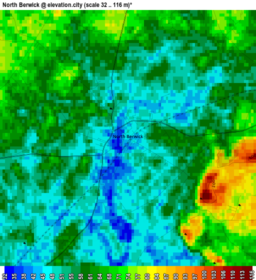
Below is the Elevation map of North Berwick, which displays elevation range with different colors. Scale of the first map is from 32 to 116 m (105 to 381 ft) with average elevation of 58.7 meters (=193 ft) [note 1]
These maps also provides idea of topography and contour of this city, they are displayed at different zoom levels. More info about maps, scale and edge coordinates you can find below images.
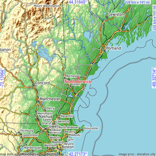
| \ | Map #1 | Topo.Map |
| Scale [m] | 32..116 m | × |
| Scale [ft] | 105..381 ft | × |
| Average | 58.7 m = 193 ft | × |
| Width | 7.11 km = 4.4 mi | 227.6 km = 141.4 mi |
| Height | 7.11 km = 4.4 mi | 227.6 km = 141.4 mi |
| ↑Max Latitude | 43.335672° | 44.31845° |
| Latitude at center | 43.3037° | 43.3037° |
| ↓Min Latitude | 43.271711° | 42.27173° |
| ← Min Longitude | -70.777335° | -72.13964° |
| Longitude center | -70.73339° | -70.73339° |
| →Max Longitude | -70.689445° | -69.32714° |
Nearby cities:
Cities around North Berwick sort by population:
• Dover elevation 23 m
16.4 km,  223°
223°
• Sanford 96 m
15.4 km,  347°
347°
• Somersworth 69 m
11.7 km,  246°
246°
• Wells Beach Station 33 m
11.7 km,  78°
78°
• South Berwick 38 m
9.9 km, 218°
• Lebanon 90 m
13.9 km,  316°
316°
• South Sanford 86 m
12 km,  356°
356°
• Rollinsford 32 m
10.3 km, 223°
• Cape Neddick 11 m
15.3 km,  143°
143°
• Berwick 57 m
11.4 km, 248°
• Ogunquit 13 m
12.4 km,  119°
119°
• West Kennebunk 48 m
16.9 km,  46°
46°
Multilingual:
 En español:
North Berwick elevación 43 m.
 En France:
North Berwick élévation 43 m.
 Auf Deutsch:
North Berwick höhe über dem Meeresspiegel ist 43 m.

Sources and notes:
- [note 1] Map square and city borders are not equal. Map elevation data is calculated only from area inside that square.
- [src 1] Elevation data from geonames database provided with same terms of usage.
- [src 2] The elevation map of North Berwick is generated using elevation data from NASA's 3 arcsec (90m) resolution SRTM data.
- [src 3] Base (background) map © OpenStreetMap contributors tiles are generated by Geofabrik and OpenTopoMap.
Copyright & License:
This North Berwick Elevation Map is licensed under CC BY-SA. You may reuse any part from this page, if you give a proper credit by linking to this URL:
 More info on terms of use page.