Rumford elevation
Rumford (Maine, Oxford County), United States elevation is 150 meters and Rumford elevation in feet is 492 ft above sea level [src 1]. Rumford is a populated place (feature code) with elevation that is 129 meters (423 ft) smaller than average city elevation in United States.
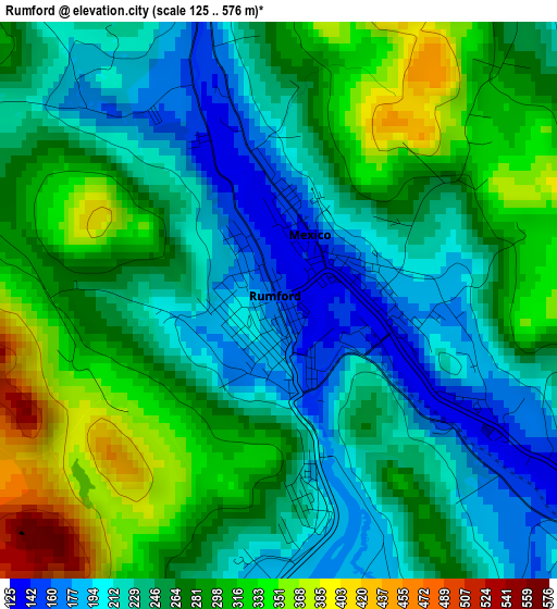
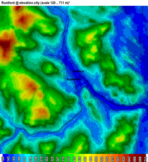
Below is the Elevation map of Rumford, which displays elevation range with different colors. Scale of the first map is from 125 to 576 m (410 to 1890 ft) with average elevation of 261.8 meters (=859 ft) [note 1]
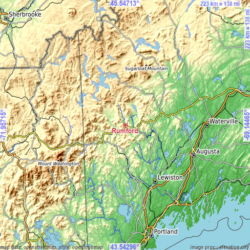
These maps also provides idea of topography and contour of this city, they are displayed at different zoom levels. More info about maps, scale and edge coordinates you can find below images.
| \ | Map #1 | Map #2 | Topo.Map |
| Scale [m] | 125..576 m | 120..711 m | × |
| Scale [ft] | 410..1890 ft | 394..2333 ft | × |
| Average | 261.8 m = 859 ft | 280.8 m = 921 ft | × |
| Width | 6.96 km = 4.3 mi | 13.93 km = 8.7 mi | 222.8 km = 138.4 mi |
| Height | 6.96 km = 4.3 mi | 13.93 km = 8.7 mi | 222.8 km = 138.4 mi |
| ↑Max Latitude | 44.584977° | 44.616267° | 45.54713° |
| Latitude at center | 44.55367° | 44.55367° | 44.55367° |
| ↓Min Latitude | 44.522346° | 44.491006° | 43.54296° |
| ← Min Longitude | -70.594845° | -70.638791° | -71.95715° |
| Longitude center | -70.5509° | -70.5509° | -70.5509° |
| →Max Longitude | -70.506955° | -70.463009° | -69.14465° |
Nearby cities:
Cities around Rumford sort by population:
• Jay elevation 116 m
27.1 km,  101°
101°
• Bethel 224 m
25.3 km,  228°
228°
• Wilton 168 m
25.9 km,  80°
80°
• West Paris 151 m
25.6 km,  184°
184°
• Mexico 148 m
0.9 km,  28°
28°
• Livermore Falls 122 m
30.1 km,  106°
106°
• Peru 124 m
12.7 km, 114°
• Chisholm 126 m
29 km, 106°
• Woodstock 264 m
20.4 km,  192°
192°
• Canton 121 m
22.4 km,  124°
124°
• Dixfield 133 m
7.8 km, 106°
• Hartford 141 m
25.8 km,  141°
141°
Multilingual:
 En español:
Rumford elevación 150 m.
 En France:
Rumford élévation 150 m.


Sources and notes:
- [note 1] Map square and city borders are not equal. Map elevation data is calculated only from area inside that square.
- [src 1] Elevation data from geonames database provided with same terms of usage.
- [src 2] The elevation map of Rumford is generated using elevation data from NASA's 3 arcsec (90m) resolution SRTM data.
- [src 3] Base (background) map © OpenStreetMap contributors tiles are generated by Geofabrik and OpenTopoMap.
Copyright & License:
This Rumford Elevation Map is licensed under CC BY-SA. You may reuse any part from this page, if you give a proper credit by linking to this URL:
 More info on terms of use page.