West Paris elevation
West Paris (Maine, Oxford County), United States elevation is 151 meters and West Paris elevation in feet is 495 ft above sea level [src 1]. West Paris is a populated place (feature code) with elevation that is 128 meters (420 ft) smaller than average city elevation in United States.
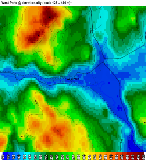
Below is the Elevation map of West Paris, which displays elevation range with different colors. Scale of the first map is from 123 to 444 m (404 to 1457 ft) with average elevation of 239.5 meters (=786 ft) [note 1]
These maps also provides idea of topography and contour of this city, they are displayed at different zoom levels. More info about maps, scale and edge coordinates you can find below images.
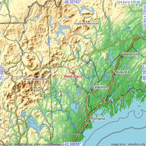
| \ | Map #1 | Topo.Map |
| Scale [m] | 123..444 m | × |
| Scale [ft] | 404..1457 ft | × |
| Average | 239.5 m = 786 ft | × |
| Width | 6.99 km = 4.3 mi | 223.7 km = 139 mi |
| Height | 6.99 km = 4.3 mi | 223.7 km = 139 mi |
| ↑Max Latitude | 44.35566° | 45.32163° |
| Latitude at center | 44.32423° | 44.32423° |
| ↓Min Latitude | 44.292783° | 43.30958° |
| ← Min Longitude | -70.617895° | -71.9802° |
| Longitude center | -70.57395° | -70.57395° |
| →Max Longitude | -70.530005° | -69.1677° |
Nearby cities:
Cities around West Paris sort by population:
• Paris elevation 247 m
9.2 km,  140°
140°
• Norway 121 m
12.5 km,  169°
169°
• Bethel 224 m
19.4 km,  297°
297°
• South Paris 118 m
12.2 km,  156°
156°
• Buckfield 114 m
17 km,  103°
103°
• Peru 124 m
24.3 km,  33°
33°
• Oxford 103 m
22.4 km, 163°
• Woodstock 264 m
6.3 km,  334°
334°
• Canton 121 m
24.2 km,  57°
57°
• Hebron 174 m
19.4 km, 136°
• Dixfield 133 m
25.1 km,  21°
21°
• Hartford 141 m
18.9 km,  73°
73°
Multilingual:
 En español:
West Paris elevación 151 m.
 En France:
West Paris élévation 151 m.
 Auf Deutsch:
West Paris höhe über dem Meeresspiegel ist 151 m.

Sources and notes:
- [note 1] Map square and city borders are not equal. Map elevation data is calculated only from area inside that square.
- [src 1] Elevation data from geonames database provided with same terms of usage.
- [src 2] The elevation map of West Paris is generated using elevation data from NASA's 3 arcsec (90m) resolution SRTM data.
- [src 3] Base (background) map © OpenStreetMap contributors tiles are generated by Geofabrik and OpenTopoMap.
Copyright & License:
This West Paris Elevation Map is licensed under CC BY-SA. You may reuse any part from this page, if you give a proper credit by linking to this URL:
 More info on terms of use page.