Jay elevation
Jay (Maine, Franklin County), United States elevation is 116 meters and Jay elevation in feet is 381 ft above sea level [src 1]. Jay is a populated place (feature code) with elevation that is 163 meters (535 ft) smaller than average city elevation in United States.
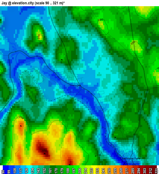
Below is the Elevation map of Jay, which displays elevation range with different colors. Scale of the first map is from 90 to 321 m (295 to 1053 ft) with average elevation of 160.8 meters (=528 ft) [note 1]
These maps also provides idea of topography and contour of this city, they are displayed at different zoom levels. More info about maps, scale and edge coordinates you can find below images.
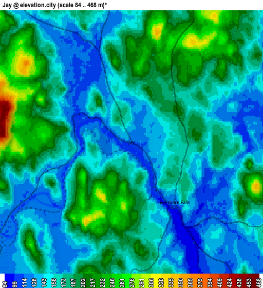
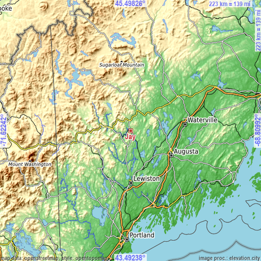
| \ | Map #1 | Map #2 | Topo.Map |
| Scale [m] | 90..321 m | 84..468 m | × |
| Scale [ft] | 295..1053 ft | 276..1535 ft | × |
| Average | 160.8 m = 528 ft | 172.9 m = 567 ft | × |
| Width | 6.97 km = 4.3 mi | 13.94 km = 8.7 mi | 223 km = 138.6 mi |
| Height | 6.97 km = 4.3 mi | 13.94 km = 8.7 mi | 223 km = 138.6 mi |
| ↑Max Latitude | 44.535283° | 44.5666° | 45.49826° |
| Latitude at center | 44.50395° | 44.50395° | 44.50395° |
| ↓Min Latitude | 44.4726° | 44.441233° | 43.49238° |
| ← Min Longitude | -70.260115° | -70.304061° | -71.62242° |
| Longitude center | -70.21617° | -70.21617° | -70.21617° |
| →Max Longitude | -70.172225° | -70.128279° | -68.80992° |
Nearby cities:
Cities around Jay sort by population:
• Farmington elevation 127 m
19.2 km,  15°
15°
• Wilton 168 m
9.9 km,  354°
354°
• Livermore 125 m
13.6 km,  191°
191°
• Livermore Falls 122 m
3.9 km,  145°
145°
• Mount Vernon 107 m
18.1 km,  90°
90°
• Peru 124 m
15 km,  271°
271°
• Chisholm 126 m
2.8 km, 152°
• Chesterville 117 m
11.6 km,  63°
63°
• Canton 121 m
10.6 km,  228°
228°
• Fayette 104 m
17.9 km,  126°
126°
• Dixfield 133 m
19.3 km,  279°
279°
• Hartford 141 m
17.9 km,  215°
215°
Multilingual:
 En español:
Jay elevación 116 m.
 En France:
Jay élévation 116 m.


Sources and notes:
- [note 1] Map square and city borders are not equal. Map elevation data is calculated only from area inside that square.
- [src 1] Elevation data from geonames database provided with same terms of usage.
- [src 2] The elevation map of Jay is generated using elevation data from NASA's 3 arcsec (90m) resolution SRTM data.
- [src 3] Base (background) map © OpenStreetMap contributors tiles are generated by Geofabrik and OpenTopoMap.
Copyright & License:
This Jay Elevation Map is licensed under CC BY-SA. You may reuse any part from this page, if you give a proper credit by linking to this URL:
 More info on terms of use page.