Westhampton elevation
Westhampton (Massachusetts, Hampshire County), United States elevation is 195 meters and Westhampton elevation in feet is 640 ft above sea level [src 1]. Westhampton is a populated place (feature code) with elevation that is 84 meters (276 ft) smaller than average city elevation in United States.
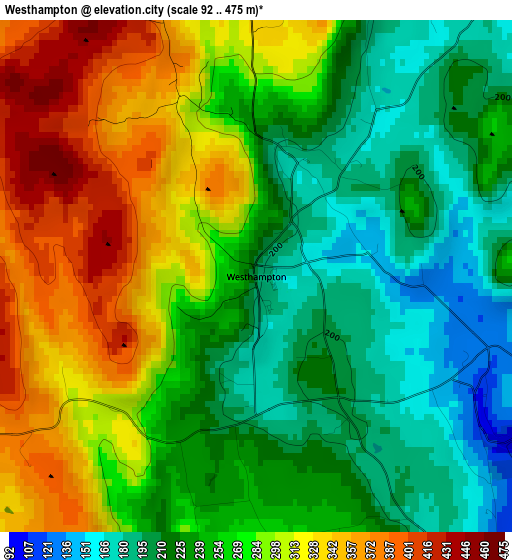
Below is the Elevation map of Westhampton, which displays elevation range with different colors. Scale of the first map is from 92 to 475 m (302 to 1558 ft) with average elevation of 264.7 meters (=868 ft) [note 1]
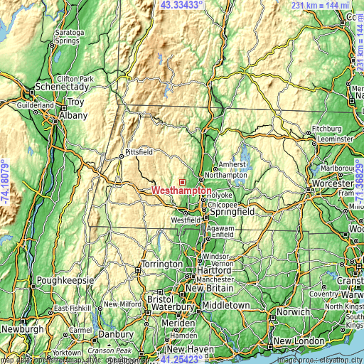
These maps also provides idea of topography and contour of this city, they are displayed at different zoom levels. More info about maps, scale and edge coordinates you can find below images.
| \ | Map #1 | Topo.Map |
| Scale [m] | 92..475 m | × |
| Scale [ft] | 302..1558 ft | × |
| Average | 264.7 m = 868 ft | × |
| Width | 7.23 km = 4.5 mi | 231.3 km = 143.7 mi |
| Height | 7.23 km = 4.5 mi | 231.3 km = 143.7 mi |
| ↑Max Latitude | 42.335363° | 43.33433° |
| Latitude at center | 42.30287° | 42.30287° |
| ↓Min Latitude | 42.27036° | 41.25423° |
| ← Min Longitude | -72.818485° | -74.18079° |
| Longitude center | -72.77454° | -72.77454° |
| →Max Longitude | -72.730595° | -71.36829° |
Nearby cities:
Cities around Westhampton sort by population:
• North Chicopee elevation 51 m
19.6 km,  132°
132°
• Westfield 47 m
19.9 km,  174°
174°
• Holyoke 61 m
17 km, 130°
• Northampton 86 m
11.2 km,  77°
77°
• South Hadley 81 m
17.2 km,  106°
106°
• Easthampton 53 m
9.6 km, 114°
• Southampton 75 m
9 km,  155°
155°
• Hadley 47 m
15.9 km,  74°
74°
• Williamsburg 169 m
10.7 km,  19°
19°
• Whately 92 m
19.1 km,  37°
37°
• Hatfield 45 m
16.4 km,  62°
62°
• Chesterfield 439 m
11.2 km,  331°
331°
Multilingual:
 En español:
Westhampton elevación 195 m.
 En France:
Westhampton élévation 195 m.
 Auf Deutsch:
Westhampton höhe über dem Meeresspiegel ist 195 m.

Sources and notes:
- [note 1] Map square and city borders are not equal. Map elevation data is calculated only from area inside that square.
- [src 1] Elevation data from geonames database provided with same terms of usage.
- [src 2] The elevation map of Westhampton is generated using elevation data from NASA's 3 arcsec (90m) resolution SRTM data.
- [src 3] Base (background) map © OpenStreetMap contributors tiles are generated by Geofabrik and OpenTopoMap.
Copyright & License:
This Westhampton Elevation Map is licensed under CC BY-SA. You may reuse any part from this page, if you give a proper credit by linking to this URL:
 More info on terms of use page.