Westfield elevation
Westfield (Massachusetts, Hampden County), United States elevation is 47 meters and Westfield elevation in feet is 154 ft above sea level [src 1]. Westfield is a populated place (feature code) with elevation that is 232 meters (761 ft) smaller than average city elevation in United States.
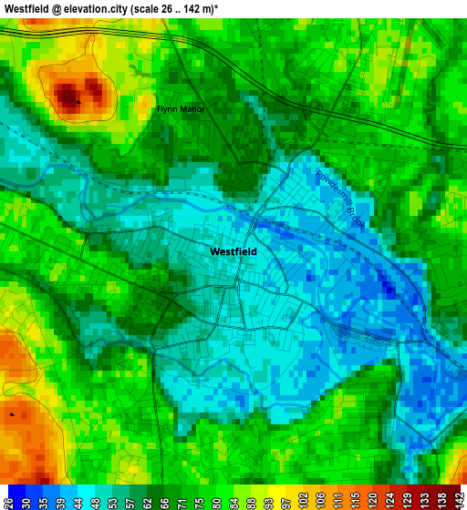
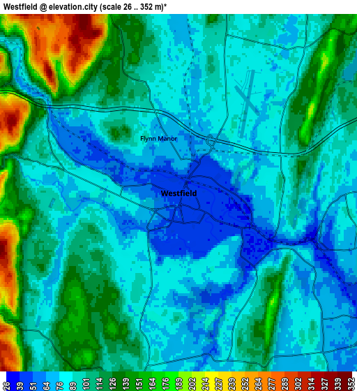
Below is the Elevation map of Westfield, which displays elevation range with different colors. Scale of the first map is from 26 to 142 m (85 to 466 ft) with average elevation of 67.9 meters (=223 ft) [note 1]
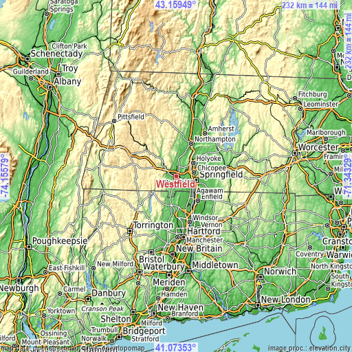
These maps also provides idea of topography and contour of this city, they are displayed at different zoom levels. More info about maps, scale and edge coordinates you can find below images.
| \ | Map #1 | Map #2 | Topo.Map |
| Scale [m] | 26..142 m | 26..352 m | × |
| Scale [ft] | 85..466 ft | 85..1155 ft | × |
| Average | 67.9 m = 223 ft | 101.8 m = 334 ft | × |
| Width | 7.25 km = 4.5 mi | 14.5 km = 9 mi | 231.9 km = 144.1 mi |
| Height | 7.25 km = 4.5 mi | 14.5 km = 9 mi | 231.9 km = 144.1 mi |
| ↑Max Latitude | 42.157675° | 42.190243° | 43.15949° |
| Latitude at center | 42.12509° | 42.12509° | 42.12509° |
| ↓Min Latitude | 42.092488° | 42.05987° | 41.07353° |
| ← Min Longitude | -72.793485° | -72.837431° | -74.15579° |
| Longitude center | -72.74954° | -72.74954° | -72.74954° |
| →Max Longitude | -72.705595° | -72.661649° | -71.34329° |
Nearby cities:
Cities around Westfield sort by population:
• Springfield elevation 49 m
13.4 km,  101°
101°
• Chicopee 31 m
12 km,  77°
77°
• North Chicopee 51 m
14 km,  62°
62°
• Holyoke 61 m
14.1 km,  51°
51°
• Agawam 28 m
12.7 km,  119°
119°
• West Springfield 26 m
10.8 km, 100°
• Easthampton 53 m
17.1 km,  22°
22°
• Longmeadow 50 m
16.1 km, 121°
• Southwick 75 m
8 km,  192°
192°
• Southampton 75 m
11.7 km,  7°
7°
• North Granby 86 m
15.8 km,  204°
204°
• Granville 211 m
11.3 km,  234°
234°
Multilingual:
 En español:
Westfield elevación 47 m.
 En France:
Westfield élévation 47 m.
 Auf Deutsch:
Westfield höhe über dem Meeresspiegel ist 47 m.

Sources and notes:
- [note 1] Map square and city borders are not equal. Map elevation data is calculated only from area inside that square.
- [src 1] Elevation data from geonames database provided with same terms of usage.
- [src 2] The elevation map of Westfield is generated using elevation data from NASA's 3 arcsec (90m) resolution SRTM data.
- [src 3] Base (background) map © OpenStreetMap contributors tiles are generated by Geofabrik and OpenTopoMap.
Copyright & License:
This Westfield Elevation Map is licensed under CC BY-SA. You may reuse any part from this page, if you give a proper credit by linking to this URL:
 More info on terms of use page.