Chesterfield elevation
Chesterfield (Massachusetts, Hampshire County), United States elevation is 439 meters and Chesterfield elevation in feet is 1440 ft above sea level [src 1]. Chesterfield is a populated place (feature code) with elevation that is 160 meters (525 ft) bigger than average city elevation in United States.
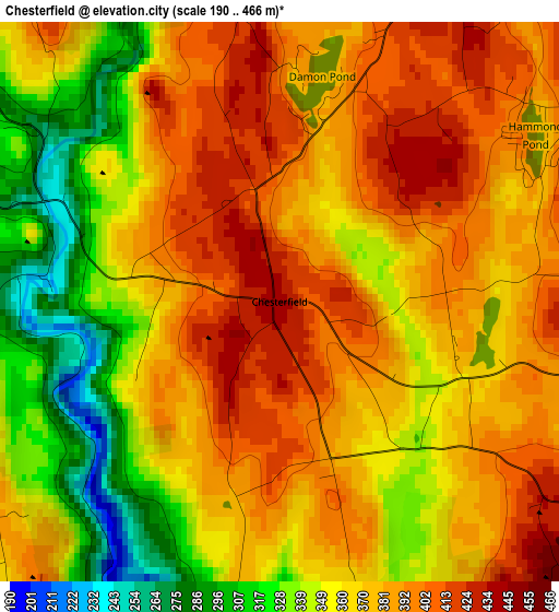
Below is the Elevation map of Chesterfield, which displays elevation range with different colors. Scale of the first map is from 190 to 466 m (623 to 1529 ft) with average elevation of 370 meters (=1214 ft) [note 1]
These maps also provides idea of topography and contour of this city, they are displayed at different zoom levels. More info about maps, scale and edge coordinates you can find below images.
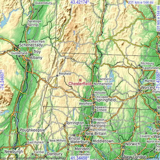
| \ | Map #1 | Topo.Map |
| Scale [m] | 190..466 m | × |
| Scale [ft] | 623..1529 ft | × |
| Average | 370 m = 1214 ft | × |
| Width | 7.22 km = 4.5 mi | 231 km = 143.5 mi |
| Height | 7.22 km = 4.5 mi | 231 km = 143.5 mi |
| ↑Max Latitude | 42.424198° | 43.42174° |
| Latitude at center | 42.39175° | 42.39175° |
| ↓Min Latitude | 42.359286° | 41.34458° |
| ← Min Longitude | -72.883765° | -74.24607° |
| Longitude center | -72.83982° | -72.83982° |
| →Max Longitude | -72.795875° | -71.43357° |
Nearby cities:
Cities around Chesterfield sort by population:
• Northampton elevation 86 m
17.9 km,  114°
114°
• Easthampton 53 m
19.8 km,  134°
134°
• Southampton 75 m
20.2 km,  153°
153°
• Hadley 47 m
21.4 km, 105°
• Williamsburg 169 m
9 km,  89°
89°
• South Deerfield 65 m
21.3 km,  63°
63°
• Conway 185 m
17.5 km,  41°
41°
• Ashfield 382 m
15.6 km,  15°
15°
• Becket 372 m
21 km,  251°
251°
• Whately 92 m
17.7 km,  72°
72°
• Westhampton 195 m
11.2 km, 151°
• Hatfield 45 m
20 km,  96°
96°
Multilingual:
 En español:
Chesterfield elevación 439 m.
 En France:
Chesterfield élévation 439 m.
 Auf Deutsch:
Chesterfield höhe über dem Meeresspiegel ist 439 m.

Sources and notes:
- [note 1] Map square and city borders are not equal. Map elevation data is calculated only from area inside that square.
- [src 1] Elevation data from geonames database provided with same terms of usage.
- [src 2] The elevation map of Chesterfield is generated using elevation data from NASA's 3 arcsec (90m) resolution SRTM data.
- [src 3] Base (background) map © OpenStreetMap contributors tiles are generated by Geofabrik and OpenTopoMap.
Copyright & License:
This Chesterfield Elevation Map is licensed under CC BY-SA. You may reuse any part from this page, if you give a proper credit by linking to this URL:
 More info on terms of use page.