Paxton elevation
Paxton (Massachusetts, Worcester County), United States elevation is 346 meters and Paxton elevation in feet is 1135 ft above sea level [src 1]. Paxton is a populated place (feature code) with elevation that is 67 meters (220 ft) bigger than average city elevation in United States.
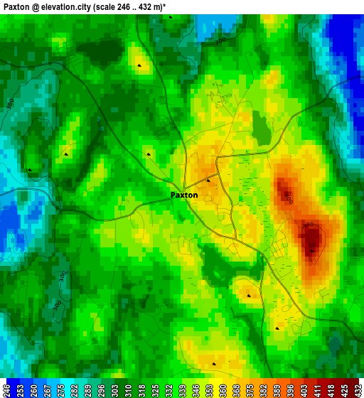
Below is the Elevation map of Paxton, which displays elevation range with different colors. Scale of the first map is from 246 to 432 m (807 to 1417 ft) with average elevation of 325.1 meters (=1067 ft) [note 1]
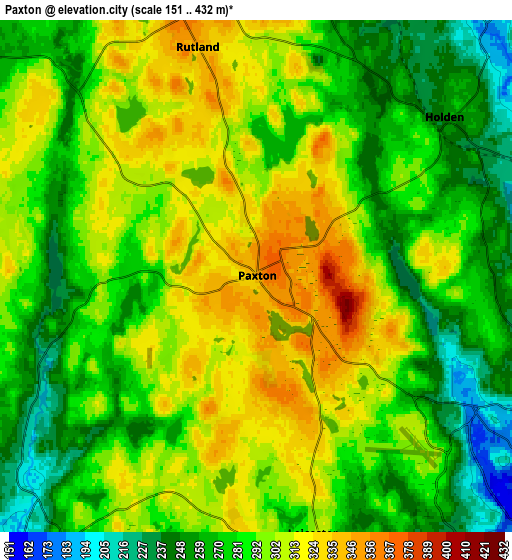
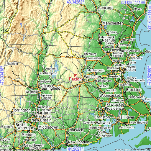
These maps also provides idea of topography and contour of this city, they are displayed at different zoom levels. More info about maps, scale and edge coordinates you can find below images.
| \ | Map #1 | Map #2 | Topo.Map |
| Scale [m] | 246..432 m | 151..432 m | × |
| Scale [ft] | 807..1417 ft | 495..1417 ft | × |
| Average | 325.1 m = 1067 ft | 288.7 m = 947 ft | × |
| Width | 7.23 km = 4.5 mi | 14.45 km = 9 mi | 231.3 km = 143.7 mi |
| Height | 7.23 km = 4.5 mi | 14.45 km = 9 mi | 231.2 km = 143.7 mi |
| ↑Max Latitude | 42.343689° | 42.376162° | 43.34252° |
| Latitude at center | 42.3112° | 42.3112° | 42.3112° |
| ↓Min Latitude | 42.278694° | 42.246171° | 41.2627° |
| ← Min Longitude | -71.972075° | -72.016021° | -73.33438° |
| Longitude center | -71.92813° | -71.92813° | -71.92813° |
| →Max Longitude | -71.884185° | -71.840239° | -70.52188° |
Nearby cities:
Cities around Paxton sort by population:
• Worcester elevation 164 m
11.7 km,  117°
117°
• Holden 253 m
7 km,  49°
49°
• Auburn 189 m
15 km,  149°
149°
• Leicester 302 m
7.4 km,  167°
167°
• Hamilton Worcester 153 m
14.6 km,  114°
114°
• West Boylston 168 m
13.2 km,  62°
62°
• Spencer 264 m
9.2 km,  215°
215°
• Sunderland 157 m
14.8 km, 119°
• North Brookfield 269 m
13.7 km,  248°
248°
• Rutland 347 m
6.7 km,  345°
345°
• Oakham 328 m
10.7 km,  295°
295°
• East Brookfield 187 m
13.5 km,  226°
226°
Multilingual:
 En español:
Paxton elevación 346 m.
 En France:
Paxton élévation 346 m.


Sources and notes:
- [note 1] Map square and city borders are not equal. Map elevation data is calculated only from area inside that square.
- [src 1] Elevation data from geonames database provided with same terms of usage.
- [src 2] The elevation map of Paxton is generated using elevation data from NASA's 3 arcsec (90m) resolution SRTM data.
- [src 3] Base (background) map © OpenStreetMap contributors tiles are generated by Geofabrik and OpenTopoMap.
Copyright & License:
This Paxton Elevation Map is licensed under CC BY-SA. You may reuse any part from this page, if you give a proper credit by linking to this URL:
 More info on terms of use page.