Auburn elevation
Auburn (Massachusetts, Worcester County), United States elevation is 189 meters and Auburn elevation in feet is 620 ft above sea level [src 1]. Auburn is a populated place (feature code) with elevation that is 90 meters (295 ft) smaller than average city elevation in United States.
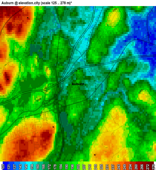
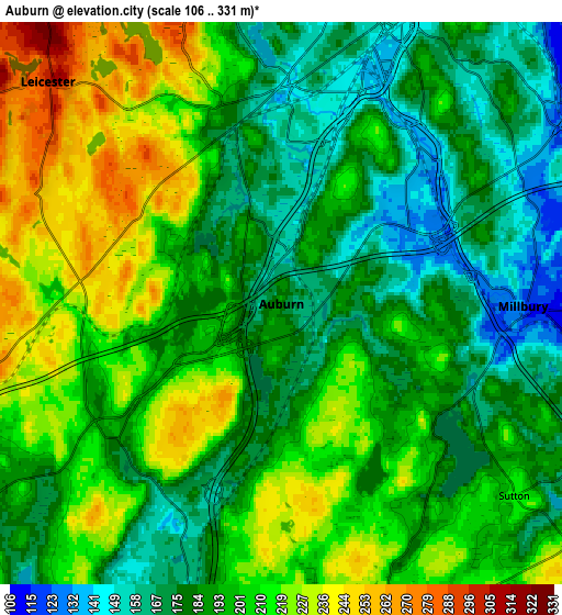
Below is the Elevation map of Auburn, which displays elevation range with different colors. Scale of the first map is from 125 to 278 m (410 to 912 ft) with average elevation of 189.1 meters (=620 ft) [note 1]
These maps also provides idea of topography and contour of this city, they are displayed at different zoom levels. More info about maps, scale and edge coordinates you can find below images.
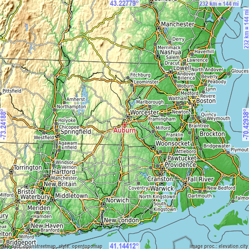
| \ | Map #1 | Map #2 | Topo.Map |
| Scale [m] | 125..278 m | 106..331 m | × |
| Scale [ft] | 410..912 ft | 348..1086 ft | × |
| Average | 189.1 m = 620 ft | 196.7 m = 645 ft | × |
| Width | 7.24 km = 4.5 mi | 14.48 km = 9 mi | 231.7 km = 144 mi |
| Height | 7.24 km = 4.5 mi | 14.48 km = 9 mi | 231.7 km = 144 mi |
| ↑Max Latitude | 42.227089° | 42.259622° | 43.22779° |
| Latitude at center | 42.19454° | 42.19454° | 42.19454° |
| ↓Min Latitude | 42.161974° | 42.129391° | 41.14412° |
| ← Min Longitude | -71.879575° | -71.923521° | -73.24188° |
| Longitude center | -71.83563° | -71.83563° | -71.83563° |
| →Max Longitude | -71.791685° | -71.747739° | -70.42938° |
Nearby cities:
Cities around Auburn sort by population:
• Worcester elevation 164 m
8 km,  19°
19°
• Shrewsbury 199 m
15.1 km,  41°
41°
• Grafton 149 m
12.4 km,  83°
83°
• Millbury 124 m
6.2 km,  90°
90°
• Charlton 272 m
12.9 km,  239°
239°
• Leicester 302 m
8.3 km,  313°
313°
• Sutton 218 m
7.8 km,  129°
129°
• Hamilton Worcester 153 m
8.9 km, 39°
• Oxford 156 m
9 km,  195°
195°
• Spencer 264 m
14 km,  293°
293°
• Paxton 346 m
15 km,  329°
329°
• Sunderland 157 m
7.7 km, 43°
Multilingual:
 En español:
Auburn elevación 189 m.
 En France:
Auburn élévation 189 m.


Sources and notes:
- [note 1] Map square and city borders are not equal. Map elevation data is calculated only from area inside that square.
- [src 1] Elevation data from geonames database provided with same terms of usage.
- [src 2] The elevation map of Auburn is generated using elevation data from NASA's 3 arcsec (90m) resolution SRTM data.
- [src 3] Base (background) map © OpenStreetMap contributors tiles are generated by Geofabrik and OpenTopoMap.
Copyright & License:
This Auburn Elevation Map is licensed under CC BY-SA. You may reuse any part from this page, if you give a proper credit by linking to this URL:
 More info on terms of use page.