Holland elevation
Holland (Massachusetts, Hampden County), United States elevation is 227 meters and Holland elevation in feet is 745 ft above sea level [src 1]. Holland is a populated place (feature code) with elevation that is 52 meters (171 ft) smaller than average city elevation in United States.
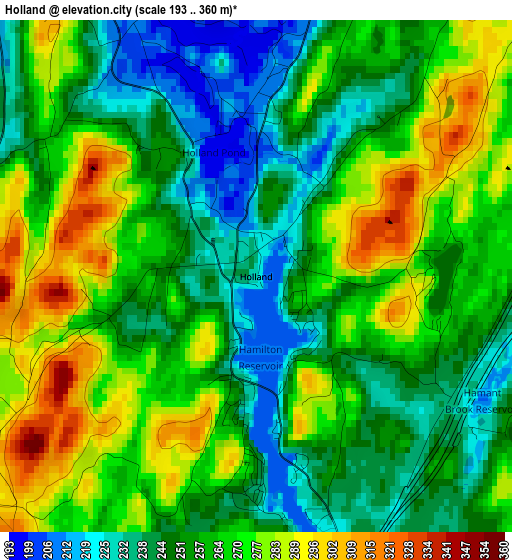
Below is the Elevation map of Holland, which displays elevation range with different colors. Scale of the first map is from 193 to 360 m (633 to 1181 ft) with average elevation of 259.9 meters (=853 ft) [note 1]
These maps also provides idea of topography and contour of this city, they are displayed at different zoom levels. More info about maps, scale and edge coordinates you can find below images.
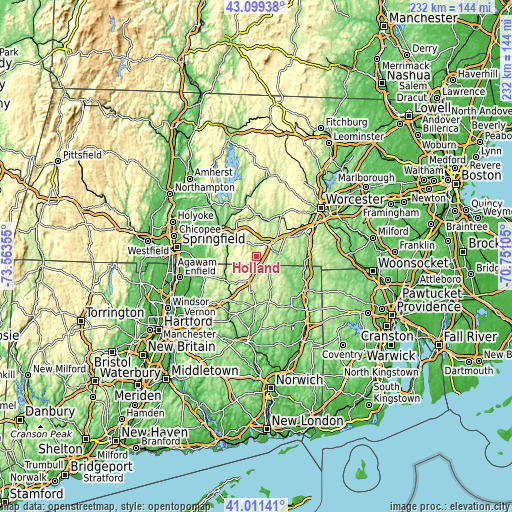
| \ | Map #1 | Topo.Map |
| Scale [m] | 193..360 m | × |
| Scale [ft] | 633..1181 ft | × |
| Average | 259.9 m = 853 ft | × |
| Width | 7.26 km = 4.5 mi | 232.2 km = 144.3 mi |
| Height | 7.26 km = 4.5 mi | 232.2 km = 144.3 mi |
| ↑Max Latitude | 42.096596° | 43.09938° |
| Latitude at center | 42.06398° | 42.06398° |
| ↓Min Latitude | 42.031347° | 41.01141° |
| ← Min Longitude | -72.201245° | -73.56355° |
| Longitude center | -72.1573° | -72.1573° |
| →Max Longitude | -72.113355° | -70.75105° |
Nearby cities:
Cities around Holland sort by population:
• Southbridge elevation 152 m
10.3 km,  83°
83°
• Palmer 109 m
17.6 km,  306°
306°
• Charlton 272 m
17.4 km,  62°
62°
• Stafford 181 m
14 km,  231°
231°
• Monson 138 m
14.1 km,  288°
288°
• Stafford Springs 153 m
17.1 km,  224°
224°
• Brimfield 207 m
7.5 km,  331°
331°
• Fiskdale 182 m
6.8 km,  31°
31°
• Sturbridge 183 m
8.2 km,  52°
52°
• Monson Center 174 m
12.8 km, 287°
• Wales 294 m
5.4 km,  276°
276°
• Warren 200 m
16.8 km,  350°
350°
Multilingual:
 En español:
Holland elevación 227 m.
 En France:
Holland élévation 227 m.


Sources and notes:
- [note 1] Map square and city borders are not equal. Map elevation data is calculated only from area inside that square.
- [src 1] Elevation data from geonames database provided with same terms of usage.
- [src 2] The elevation map of Holland is generated using elevation data from NASA's 3 arcsec (90m) resolution SRTM data.
- [src 3] Base (background) map © OpenStreetMap contributors tiles are generated by Geofabrik and OpenTopoMap.
Copyright & License:
This Holland Elevation Map is licensed under CC BY-SA. You may reuse any part from this page, if you give a proper credit by linking to this URL:
 More info on terms of use page.