Rossville elevation
Rossville (Illinois, Vermilion County), United States elevation is 213 meters and Rossville elevation in feet is 699 ft above sea level [src 1]. Rossville is a populated place (feature code) with elevation that is 66 meters (217 ft) smaller than average city elevation in United States.
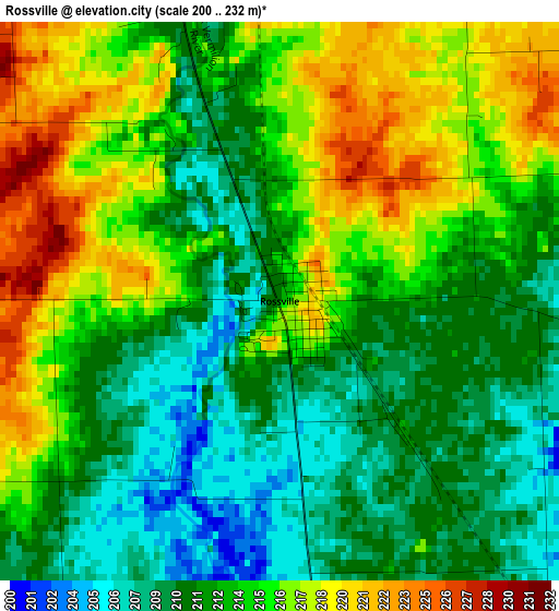
Below is the Elevation map of Rossville, which displays elevation range with different colors. Scale of the first map is from 200 to 232 m (656 to 761 ft) with average elevation of 213.4 meters (=700 ft) [note 1]
These maps also provides idea of topography and contour of this city, they are displayed at different zoom levels. More info about maps, scale and edge coordinates you can find below images.
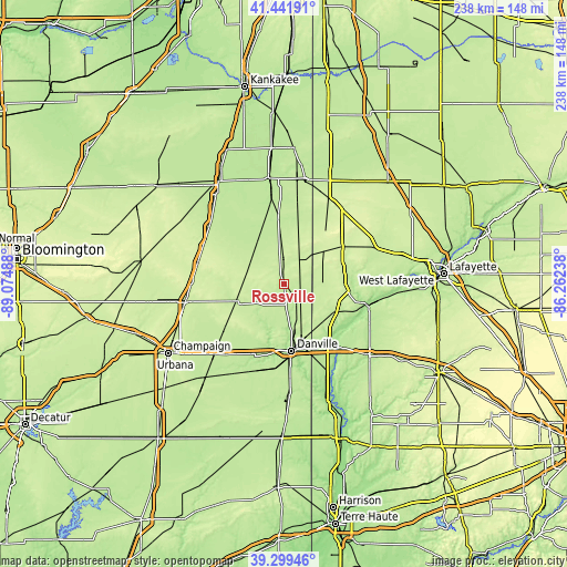
| \ | Map #1 | Topo.Map |
| Scale [m] | 200..232 m | × |
| Scale [ft] | 656..761 ft | × |
| Average | 213.4 m = 700 ft | × |
| Width | 7.44 km = 4.6 mi | 238.2 km = 148 mi |
| Height | 7.44 km = 4.6 mi | 238.2 km = 148 mi |
| ↑Max Latitude | 40.412668° | 41.44191° |
| Latitude at center | 40.3792° | 40.3792° |
| ↓Min Latitude | 40.345715° | 39.29946° |
| ← Min Longitude | -87.712575° | -89.07488° |
| Longitude center | -87.66863° | -87.66863° |
| →Max Longitude | -87.624685° | -86.26238° |
Nearby cities:
Cities around Rossville sort by population:
• Danville elevation 189 m
28.5 km,  173°
173°
• Hoopeston 224 m
9.8 km,  0°
0°
• Paxton 245 m
37.2 km,  284°
284°
• Attica 167 m
36.8 km,  104°
104°
• Westville 205 m
37.6 km,  176°
176°
• Tilton 200 m
31.6 km, 176°
• Covington 177 m
35.2 km,  138°
138°
• Catlin 201 m
35 km, 184°
• Williamsport 195 m
33.3 km,  107°
107°
• Oakwood 198 m
30.7 km,  197°
197°
• Milford 206 m
27.8 km,  355°
355°
• Gifford 245 m
31 km,  254°
254°
Multilingual:
 En español:
Rossville elevación 213 m.
 En France:
Rossville élévation 213 m.
 Auf Deutsch:
Rossville höhe über dem Meeresspiegel ist 213 m.

Sources and notes:
- [note 1] Map square and city borders are not equal. Map elevation data is calculated only from area inside that square.
- [src 1] Elevation data from geonames database provided with same terms of usage.
- [src 2] The elevation map of Rossville is generated using elevation data from NASA's 3 arcsec (90m) resolution SRTM data.
- [src 3] Base (background) map © OpenStreetMap contributors tiles are generated by Geofabrik and OpenTopoMap.
Copyright & License:
This Rossville Elevation Map is licensed under CC BY-SA. You may reuse any part from this page, if you give a proper credit by linking to this URL:
 More info on terms of use page.