Westville elevation
Westville (Illinois, Vermilion County), United States elevation is 205 meters and Westville elevation in feet is 673 ft above sea level [src 1]. Westville is a populated place (feature code) with elevation that is 74 meters (243 ft) smaller than average city elevation in United States.
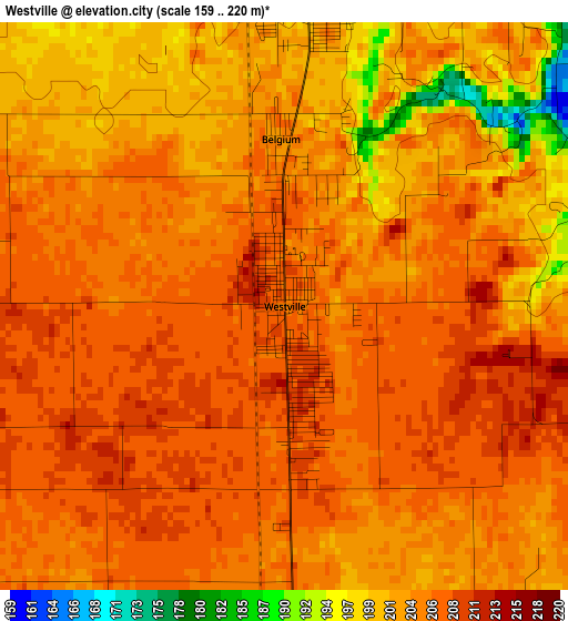
Below is the Elevation map of Westville, which displays elevation range with different colors. Scale of the first map is from 159 to 220 m (522 to 722 ft) with average elevation of 204.1 meters (=670 ft) [note 1]
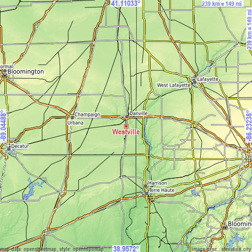
These maps also provides idea of topography and contour of this city, they are displayed at different zoom levels. More info about maps, scale and edge coordinates you can find below images.
| \ | Map #1 | Topo.Map |
| Scale [m] | 159..220 m | × |
| Scale [ft] | 522..722 ft | × |
| Average | 204.1 m = 670 ft | × |
| Width | 7.48 km = 4.6 mi | 239.4 km = 148.8 mi |
| Height | 7.48 km = 4.6 mi | 239.4 km = 148.8 mi |
| ↑Max Latitude | 40.075895° | 41.11033° |
| Latitude at center | 40.04226° | 40.04226° |
| ↓Min Latitude | 40.008608° | 38.9572° |
| ← Min Longitude | -87.682575° | -89.04488° |
| Longitude center | -87.63863° | -87.63863° |
| →Max Longitude | -87.594685° | -86.23238° |
Nearby cities:
Cities around Westville sort by population:
• Danville elevation 189 m
9.2 km,  4°
4°
• Saint Joseph 205 m
35.2 km,  282°
282°
• Georgetown 205 m
7.4 km,  178°
178°
• Tilton 200 m
5.9 km,  352°
352°
• Covington 177 m
23.5 km,  61°
61°
• Veedersburg 196 m
33 km,  76°
76°
• Catlin 201 m
6 km,  295°
295°
• Oakwood 198 m
14.5 km, 304°
• Chrisman 198 m
26.7 km,  186°
186°
• Homer 206 m
27.2 km,  268°
268°
• Cayuga 157 m
18.5 km,  124°
124°
• Newport 164 m
26.3 km,  131°
131°
Multilingual:
 En español:
Westville elevación 205 m.
 En France:
Westville élévation 205 m.
 Auf Deutsch:
Westville höhe über dem Meeresspiegel ist 205 m.

Sources and notes:
- [note 1] Map square and city borders are not equal. Map elevation data is calculated only from area inside that square.
- [src 1] Elevation data from geonames database provided with same terms of usage.
- [src 2] The elevation map of Westville is generated using elevation data from NASA's 3 arcsec (90m) resolution SRTM data.
- [src 3] Base (background) map © OpenStreetMap contributors tiles are generated by Geofabrik and OpenTopoMap.
Copyright & License:
This Westville Elevation Map is licensed under CC BY-SA. You may reuse any part from this page, if you give a proper credit by linking to this URL:
 More info on terms of use page.