Paxton elevation
Paxton (Illinois, Ford County), United States elevation is 245 meters and Paxton elevation in feet is 804 ft above sea level [src 1]. Paxton is a seat of a second-order administrative division (feature code) with elevation that is 34 meters (112 ft) smaller than average city elevation in United States.
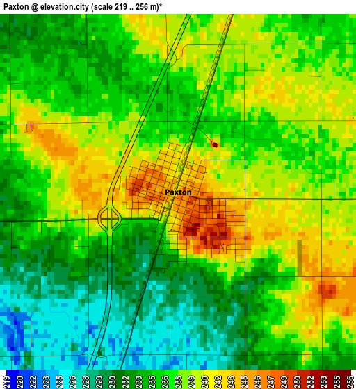
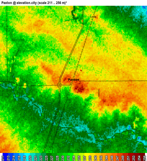
Below is the Elevation map of Paxton, which displays elevation range with different colors. Scale of the first map is from 219 to 256 m (719 to 840 ft) with average elevation of 236.2 meters (=775 ft) [note 1]
These maps also provides idea of topography and contour of this city, they are displayed at different zoom levels. More info about maps, scale and edge coordinates you can find below images.
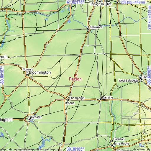
| \ | Map #1 | Map #2 | Topo.Map |
| Scale [m] | 219..256 m | 211..256 m | × |
| Scale [ft] | 719..840 ft | 692..840 ft | × |
| Average | 236.2 m = 775 ft | 233.2 m = 765 ft | × |
| Width | 7.44 km = 4.6 mi | 14.87 km = 9.2 mi | 237.9 km = 147.8 mi |
| Height | 7.44 km = 4.6 mi | 14.87 km = 9.2 mi | 237.9 km = 147.8 mi |
| ↑Max Latitude | 40.493738° | 40.527149° | 41.52173° |
| Latitude at center | 40.46031° | 40.46031° | 40.46031° |
| ↓Min Latitude | 40.426866° | 40.393405° | 39.38185° |
| ← Min Longitude | -88.139265° | -88.183211° | -89.50157° |
| Longitude center | -88.09532° | -88.09532° | -88.09532° |
| →Max Longitude | -88.051375° | -88.007429° | -86.68907° |
Nearby cities:
Cities around Paxton sort by population:
• Rantoul elevation 229 m
17.7 km,  196°
196°
• Hoopeston 224 m
36.1 km,  88°
88°
• Gibson City 226 m
24.5 km,  269°
269°
• Lake of the Woods 229 m
36.5 km,  219°
219°
• Fisher 220 m
27 km,  233°
233°
• Gilman 201 m
35.2 km,  14°
14°
• Onarga 206 m
29.3 km, 14°
• Rossville 213 m
37.2 km,  104°
104°
• Milford 206 m
38.6 km,  61°
61°
• Chatsworth 228 m
36.6 km,  333°
333°
• Thomasboro 225 m
25.4 km, 197°
• Gifford 245 m
18.3 km,  159°
159°
Multilingual:
 En español:
Paxton elevación 245 m.
 En France:
Paxton élévation 245 m.


Sources and notes:
- [note 1] Map square and city borders are not equal. Map elevation data is calculated only from area inside that square.
- [src 1] Elevation data from geonames database provided with same terms of usage.
- [src 2] The elevation map of Paxton is generated using elevation data from NASA's 3 arcsec (90m) resolution SRTM data.
- [src 3] Base (background) map © OpenStreetMap contributors tiles are generated by Geofabrik and OpenTopoMap.
Copyright & License:
This Paxton Elevation Map is licensed under CC BY-SA. You may reuse any part from this page, if you give a proper credit by linking to this URL:
 More info on terms of use page.