Heyworth elevation
Heyworth (Illinois, McLean County), United States elevation is 233 meters and Heyworth elevation in feet is 764 ft above sea level [src 1]. Heyworth is a populated place (feature code) with elevation that is 46 meters (151 ft) smaller than average city elevation in United States.
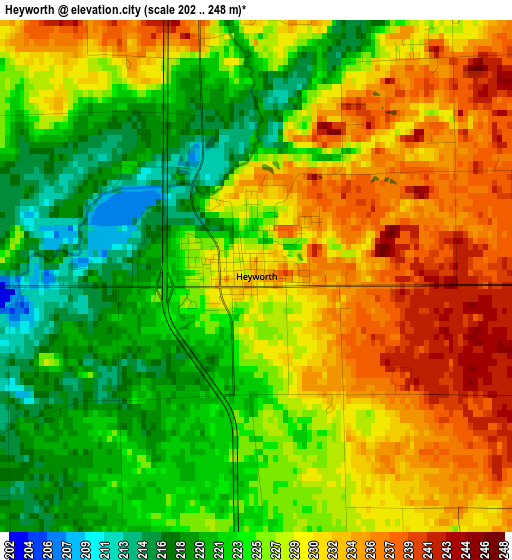
Below is the Elevation map of Heyworth, which displays elevation range with different colors. Scale of the first map is from 202 to 248 m (663 to 814 ft) with average elevation of 227 meters (=745 ft) [note 1]
These maps also provides idea of topography and contour of this city, they are displayed at different zoom levels. More info about maps, scale and edge coordinates you can find below images.
| \ | Map #1 | Topo.Map |
| Scale [m] | 202..248 m | × |
| Scale [ft] | 663..814 ft | × |
| Average | 227 m = 745 ft | × |
| Width | 7.45 km = 4.6 mi | 238.5 km = 148.2 mi |
| Height | 7.45 km = 4.6 mi | 238.4 km = 148.1 mi |
| ↑Max Latitude | 40.346871° | 41.37713° |
| Latitude at center | 40.31337° | 40.31337° |
| ↓Min Latitude | 40.279853° | 39.23259° |
| ← Min Longitude | -89.017635° | -90.37994° |
| Longitude center | -88.97369° | -88.97369° |
| →Max Longitude | -88.929745° | -87.56744° |
Nearby cities:
Cities around Heyworth sort by population:
• Bloomington elevation 246 m
19.1 km,  354°
354°
• Normal 248 m
22.4 km,  356°
356°
• Clinton 223 m
17.8 km,  177°
177°
• Le Roy 242 m
18.3 km,  76°
76°
• Farmer City 221 m
29.1 km,  105°
105°
• Hudson 238 m
32.5 km, 357°
• Maroa 225 m
30.8 km, 177°
• Atlanta 219 m
22.8 km,  254°
254°
• Twin Grove 250 m
21.9 km,  335°
335°
• Richmond 198 m
33.9 km,  278°
278°
• Minier 196 m
31.7 km,  294°
294°
• Danvers 251 m
29.6 km,  324°
324°
Multilingual:
 En español:
Heyworth elevación 233 m.
 En France:
Heyworth élévation 233 m.
 Auf Deutsch:
Heyworth höhe über dem Meeresspiegel ist 233 m.

Sources and notes:
- [note 1] Map square and city borders are not equal. Map elevation data is calculated only from area inside that square.
- [src 1] Elevation data from geonames database provided with same terms of usage.
- [src 2] The elevation map of Heyworth is generated using elevation data from NASA's 3 arcsec (90m) resolution SRTM data.
- [src 3] Base (background) map © OpenStreetMap contributors tiles are generated by Geofabrik and OpenTopoMap.
Copyright & License:
This Heyworth Elevation Map is licensed under CC BY-SA. You may reuse any part from this page, if you give a proper credit by linking to this URL:
 More info on terms of use page.