Atlanta elevation
Atlanta (Illinois, Logan County), United States elevation is 219 meters and Atlanta elevation in feet is 719 ft above sea level [src 1]. Atlanta is a populated place (feature code) with elevation that is 60 meters (197 ft) smaller than average city elevation in United States.
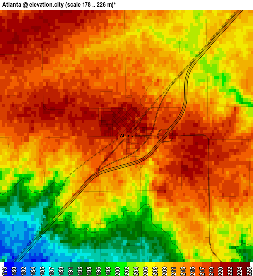
Below is the Elevation map of Atlanta, which displays elevation range with different colors. Scale of the first map is from 178 to 226 m (584 to 741 ft) with average elevation of 210.1 meters (=689 ft) [note 1]
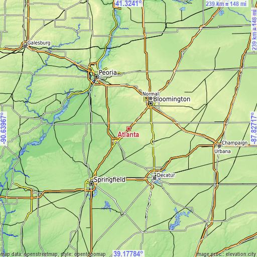
These maps also provides idea of topography and contour of this city, they are displayed at different zoom levels. More info about maps, scale and edge coordinates you can find below images.
| \ | Map #1 | Topo.Map |
| Scale [m] | 178..226 m | × |
| Scale [ft] | 584..741 ft | × |
| Average | 210.1 m = 689 ft | × |
| Width | 7.46 km = 4.6 mi | 238.6 km = 148.3 mi |
| Height | 7.46 km = 4.6 mi | 238.6 km = 148.3 mi |
| ↑Max Latitude | 40.293007° | 41.3241° |
| Latitude at center | 40.25948° | 40.25948° |
| ↓Min Latitude | 40.225936° | 39.17784° |
| ← Min Longitude | -89.277365° | -90.63967° |
| Longitude center | -89.23342° | -89.23342° |
| →Max Longitude | -89.189475° | -87.82717° |
Nearby cities:
Cities around Atlanta sort by population:
• Bloomington elevation 246 m
32.2 km,  39°
39°
• Lincoln 180 m
16.6 km,  222°
222°
• Clinton 223 m
25.7 km,  117°
117°
• Heyworth 233 m
22.8 km,  74°
74°
• Mackinaw 210 m
32.6 km,  341°
341°
• Delavan 190 m
29.4 km,  295°
295°
• Twin Grove 250 m
29.1 km,  26°
26°
• Richmond 198 m
16.1 km,  314°
314°
• Heritage Lake 227 m
33 km,  346°
346°
• Mount Pulaski 206 m
28 km,  188°
188°
• Minier 196 m
20.5 km, 340°
• Danvers 251 m
30.4 km,  8°
8°
Multilingual:
 En español:
Atlanta elevación 219 m.
 En France:
Atlanta élévation 219 m.


Sources and notes:
- [note 1] Map square and city borders are not equal. Map elevation data is calculated only from area inside that square.
- [src 1] Elevation data from geonames database provided with same terms of usage.
- [src 2] The elevation map of Atlanta is generated using elevation data from NASA's 3 arcsec (90m) resolution SRTM data.
- [src 3] Base (background) map © OpenStreetMap contributors tiles are generated by Geofabrik and OpenTopoMap.
Copyright & License:
This Atlanta Elevation Map is licensed under CC BY-SA. You may reuse any part from this page, if you give a proper credit by linking to this URL:
 More info on terms of use page.