Normal elevation
Normal (Illinois, McLean County), United States elevation is 248 meters and Normal elevation in feet is 814 ft above sea level [src 1]. Normal is a populated place (feature code) with elevation that is 31 meters (102 ft) smaller than average city elevation in United States.
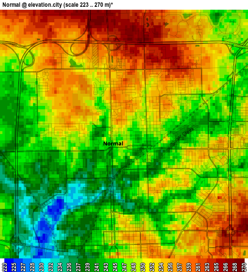
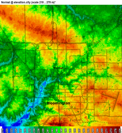
Below is the Elevation map of Normal, which displays elevation range with different colors. Scale of the first map is from 223 to 270 m (732 to 886 ft) with average elevation of 249.3 meters (=818 ft) [note 1]
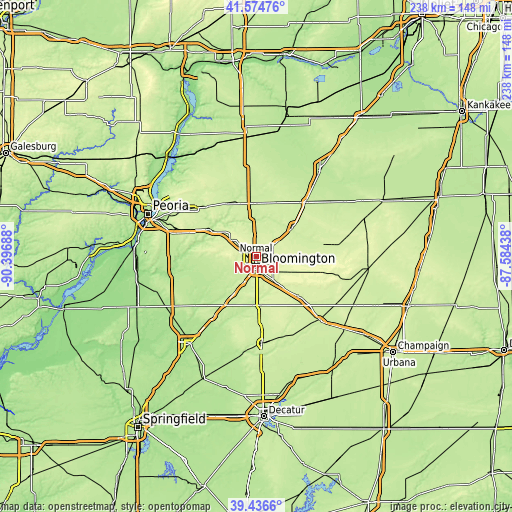
These maps also provides idea of topography and contour of this city, they are displayed at different zoom levels. More info about maps, scale and edge coordinates you can find below images.
| \ | Map #1 | Map #2 | Topo.Map |
| Scale [m] | 223..270 m | 218..278 m | × |
| Scale [ft] | 732..886 ft | 715..912 ft | × |
| Average | 249.3 m = 818 ft | 249.5 m = 819 ft | × |
| Width | 7.43 km = 4.6 mi | 14.86 km = 9.2 mi | 237.7 km = 147.7 mi |
| Height | 7.43 km = 4.6 mi | 14.86 km = 9.2 mi | 237.7 km = 147.7 mi |
| ↑Max Latitude | 40.547601° | 40.580985° | 41.57476° |
| Latitude at center | 40.5142° | 40.5142° | 40.5142° |
| ↓Min Latitude | 40.480782° | 40.447348° | 39.4366° |
| ← Min Longitude | -89.034575° | -89.078521° | -90.39688° |
| Longitude center | -88.99063° | -88.99063° | -88.99063° |
| →Max Longitude | -88.946685° | -88.902739° | -87.58438° |
Nearby cities:
Cities around Normal sort by population:
• Bloomington elevation 246 m
3.3 km,  184°
184°
• Le Roy 242 m
26.3 km,  133°
133°
• Heyworth 233 m
22.4 km, 176°
• El Paso 230 m
25.1 km,  355°
355°
• Lexington 232 m
22.5 km,  51°
51°
• Mackinaw 210 m
31.1 km,  274°
274°
• Hudson 238 m
10.2 km,  1°
1°
• Twin Grove 250 m
7.9 km,  252°
252°
• Heritage Lake 227 m
28.6 km,  277°
277°
• Gridley 232 m
27.1 km,  19°
19°
• Minier 196 m
28.7 km, 251°
• Danvers 251 m
15.9 km, 276°
Multilingual:
 En español:
Normal elevación 248 m.
 En France:
Normal élévation 248 m.
 Auf Deutsch:
Normal höhe über dem Meeresspiegel ist 248 m.
 На русском:
Нормальная, Нормал высота над уровнем моря 248 м
Sources and notes:
- [note 1] Map square and city borders are not equal. Map elevation data is calculated only from area inside that square.
- [src 1] Elevation data from geonames database provided with same terms of usage.
- [src 2] The elevation map of Normal is generated using elevation data from NASA's 3 arcsec (90m) resolution SRTM data.
- [src 3] Base (background) map © OpenStreetMap contributors tiles are generated by Geofabrik and OpenTopoMap.
Copyright & License:
This Normal Elevation Map is licensed under CC BY-SA. You may reuse any part from this page, if you give a proper credit by linking to this URL:
 More info on terms of use page.